


Multidisciplinary Geology
Integrated Analytical Approach Identifies Wolfcamp Targets Outside Defined Play Area
By Graham Spence, Austin S. Heape, Adriana Perez, Paola Fonseca, Elizabeth Roller and Cesar Marin
DALLAS–The great land grab in the Midland Basin has resulted in an exponential increase in acreage prices, with buyers paying up to $60,000 an acre in some cases. In this competitive environment, oil and gas companies–particularly smaller independents–are starting to look for prospective areas away from the main basin activity where land leasing costs can be significantly lower, drilling targets can be shallower, and reservoirs (sourced from migration) have the potential to yield economic volumes of hydrocarbon reserves.
To identify and evaluate these types of plays, and to reduce exploration and development risks, it is essential to combine and interpret data within one space to provide a succinct geological evaluation of the subsurface, and ultimately, the potential resource in place.
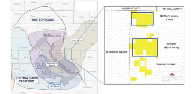
TriGeo Energy sought to conduct an integrated geological evaluation of its Wolfcamp assets in Sterling County, Tx., to identify potential drilling targets in the Eastern Shelf bordering the Midland Basin. TriGeo Energy’s leasehold is outside the current industry-defined economic boundaries of the Wolfcamp play to the west and south.
The objective was to better understand if a viable and economic Wolfcamp play could be extended onto the Eastern Shelf environment. It was essential to investigate and define the presence of the main petroleum system play elements–namely source rock quality and potential, reservoir thickness and quality, and ultimately, the presence of contained hydrocarbons.
FIGURE 1
Integrated Workflow Applied to Source Rock And Reservoir Evaluation of Wolfcamp Formation
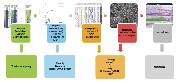
For this project, the Wolfcamp was divided into five sub-formations: A, B, Middle B, C and D, per standard industry nomenclature. Figure 1 highlights the integrated approach used on the project. The integrated evaluation utilized wireline logs from 64 wells, cuttings samples collected from recently drilled wells and public sources, geochemical data collected from drill cuttings and analyzed at state-of-the-art geochemistry laboratories, and the two 3-D seismic volumes acquired in the northern and southern areas of TriGeo Energy’s Sterling County leasehold.
A team of geochemists, petrophysicists, reservoir geologists and geophysicists worked in tandem with the operator to evaluate, integrate and interpret these datasets to better understand the Wolfcamp play’s occurrence, distribution, thickness and quality within the study area.
Forty of the 64 total wells were utilized to generate five correlation panels (three east-to-west and two north-to-south) across the study area to construct a thickness map of the Upper, Middle and Lower Wolfcamp formations. In two of the east-to-west correlation lines, public domain wells in bordering Glasscock County, Tx., west of the study area, were incorporated to assess the potential continuity of the Wolfcamp formation’s occurrence in Sterling County. This mapping process generated a gross thickness map of the Wolfcamp B, recording a thickness as great as 1,500 feet within the study area, similar to thicknesses observed in Glasscock County.
The southern edge of the “Glasscock Nose” also was identified, with the apparent thinning of the Wolfcamp B in the northern part of the study area. The newly defined Wolfcamp A, B, Middle B, C and D tops, along with the recorded thickness data, were used to select sample intervals for geochemical analyses and to isolate intervals for further petrophysical interpretation.
Geochemical Evaluation
To evaluate the petroleum system, geochemical analyses were performed on 108 cuttings samples collected from two newly drilled TriGeo Energy wells along with an additional 80 cuttings samples from two public domain wells. The geochemical analyses included total organic carbon (TOC) determination, pyrolysis and organic petrography (percentage of vitrinite reflectance). The geochemical analyses of these samples provided insight into the source rock quality across the study area, and through 1-D petroleum systems modeling, allowed the thermal evolution of the Wolfcamp formation to be evaluated within TriGeo Energy’s Sterling County acreage position.
Overall, the organic properties of the entire Wolfcamp formation at each well location showed poor to fair hydrocarbon generation ability because of low kerogen quality and maturity levels. The recorded TOC values ranged from 0.43 to 3.17 weight percent (wt%), with the Wolfcamp A averaging 1.27, the Wolfcamp B averaging 1.25 and the Wolfcamp D averaging 1.35 wt%. The remaining hydrocarbon potential and hydrogen index (HI) values indicate a decrease from the north to the south (Figure 2).
FIGURE 2
Oxygen Index versus Hydrogen Index for Evaluated Wells
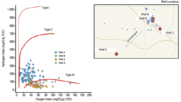
Vitrinite reflectance (%RO) measurements suggest that source rock intervals experienced a low thermal stress. The maturity in the entire Wolfcamp formation within the study area was measured as immature to early mature, with source rocks showing a slight increase in maturity toward the southern and southeastern parts of the study area, with values of ~0.7-0.8 %RO.
Taking into account the tectonic evolution of the Midland Basin and the information available from the wells (stratigraphic column, maturity, etc.) a 1-D model was built to simulate maturity through geological time. The model indicated that the maturation process started at different geological times within the study wells (dependent on well locations and thermal properties). For the most southeastern well, this process began during the Late Permian. In other parts of the study area, the maturation process started later, within the Late Triassic to Middle Jurassic, and continued through geological time.
At present-day thermal conditions recorded within the study area, wells indicate low bottom-hole temperatures (<80 degrees Celsius for corrected values), which are insufficient to continue the maturation process of the source rocks. Because of the low level of maturity and poor to fair source rock potential of the Wolfcamp formation in the study wells, it is unlikely that significant hydrocarbon volumes were generated in situ. Notwithstanding, the current wells in the study area are producing hydrocarbons from the Wolfcamp formation, suggesting that accumulated hydrocarbons may have been sourced from areas of higher maturity (such as areas that have reached the gas window) away from the Sterling County study area and/or from deeper, mature source rocks.
Testing this hypothesis further, an evaluation was performed of the gas-to-oil ratios from hydrocarbons produced from the Wolfcamp across the Midland Basin. This regional information was incorporated with the results obtained from the source rock properties collected within the study wells to create a GOR trend map of the basin. As depicted in Figure 3, the map shows higher GOR variabilities for hydrocarbons produced from the Wolfcamp across the basin, ranging from black oil to wet and dry gas. Within the study area, a trend of mixed hydrocarbons of varying GOR was observed, with most corresponding to volatile oil to wet gas and dry gas on the flanks of the Eastern Shelf.
FIGURE 3
GOR Map of Hydrocarbons Produced from
Wolfcamp Formation in Midland Basin
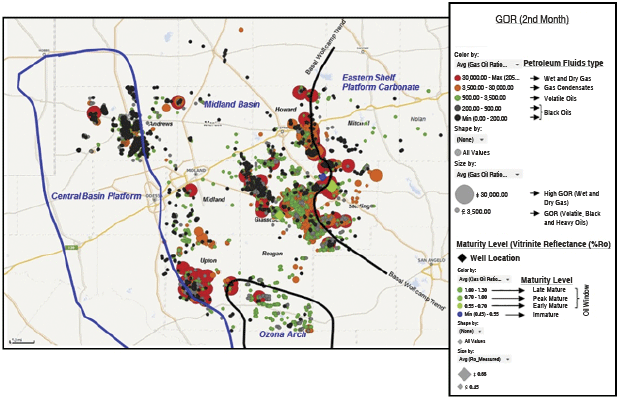
GOR variability recorded within the study area cannot be explained by the current maturity levels of the Wolfcamp formation seen in study wells. The GOR data, therefore, could represent evidence of possible mixing of hydrocarbons produced from source rocks with different maturity levels. It is proposed that gas condensate and wet/dry gas was generated from deeper source rocks such as the Woodford formation, and migrated laterally or vertically and accumulated within reservoir facies of the Wolfcamp along the Eastern Shelf Platform.
Additionally, it is likely that hydrocarbons (volatile and black oils) generated from basinal facies of the Wolfcamp formation (which host good source rock quality with higher maturity) migrated laterally within the source rock interval (primary migration) and mixed with the condensate and gas generated from the more mature source rocks. Some geochemical studies in the Permian Basin have reported many oils that exhibit intermediate geochemical characteristics indicative of mixing. Moreover, hydrocarbon migration from deeper source rocks also has been referred in the Permian Basin. Under this hypothesis, the faults and fractures would play an important role in hydrocarbon migration.
Petrophysical Analysis
To further evaluate the play’s presence, quality and hydrocarbon potential, and to test the basin center hydrocarbon migration hypothesis, six wells were selected from across the study area for petrophysical analysis. All six wells were used to derive reservoir properties, including lithology, porosity, water saturation (Sw) and pay.
Before commencing with any petrophysical calculations and interpretations, the well logs were edited and normalized to remove any logging and/or wellbore artifacts such as differing calibration methods and poor wellbore conditions to ensure sound petrophysical calculations. Elemental capture spectroscopy (ECS) and measured TOC data from the cuttings analyses were utilized to provide “real rock” constraints to the final petrophysical lithology model.
The petrophysical results highlighted that the Wolfcamp A and B host higher carbonate content, compared with the Wolfcamp Middle B, C and D, which host increased clay and quartz volumes replacing carbonate volumes. The recorded kerogen volume is reasonably constant throughout the entire Wolfcamp formation, with some thin, higher kerogen value intervals toward the top of the Wolfcamp B. Calculated effective porosity (PHIE) varies from 0 to 10 percent throughout the Wolfcamp.
To identify potential pay intervals throughout the Wolfcamp, a cutoff of greater than 5 percent PHIE and less than 60 percent Sw was applied to the petrophysical data. Intervals of higher pay lags were identified within the Wolfcamp A and B, predominately occurring in the northern study wells.
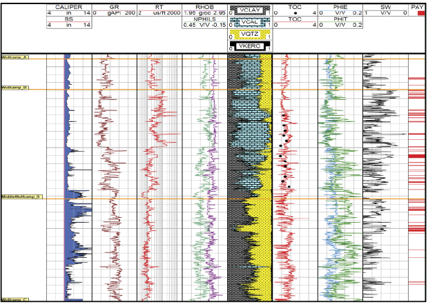
Figure 4 highlights the petrophysical outputs from one of the study wells, including edited well logs, calibrated TOC with measured TOC, calculated mineral volumes, porosity, Sw and pay throughout the Wolfcamp formation.
FIGURE 4
Petrophysical Evaluation of Wolfcamp Formation
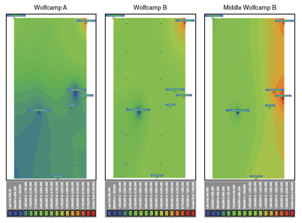
On the basis of the petrophysical calculations, specifically PHIE and Sw, and the incorporation of net Wolfcamp thickness data collected from regional correlations, seven wells were used to calculate original oil in place. The higher average OOIP values corresponded to Wolfcamp B (4.5 million barrels per 160 acres), followed by Wolfcamp A (2.5 MMbbls/160 acres) and the Wolfcamp Middle B (1.4 MMbbls/160 acres).
These results highlighted that higher amounts of oil may be accumulated in the Wolfcamp B, and more so in the northeastern area (OOIP = 7.8 MMbbls/160 acres, the highest value in a well) with the lowest accumulations to the west (OOIP = 0.9 MMbbls/160 acres, the lowest value in a well) of the study area.
Figure 5 highlights the OOIP maps for the Wolfcamp A, B and Middle B across the study area. These maps help support the evaluation of hydrocarbon accumulation within the study area and potentially the hypothesis of lateral hydrocarbon migration from the Midland Basin axis to the basin’s eastern flanks.
FIGURE 5
OOIP Maps by Formation Based on Calculated Volumes From Six Study Area Wells
By utilizing compressional velocity, shear velocity and density logs, the elastic properties of Young’s modulus and Poisson’s ratio were derived to calculate brittleness. It was found that as brittleness increases, the bulk volume of water decreases and carbonate volume increases. This suggests that these zones host higher hydrocarbon saturation and may be more susceptible to failure during hydraulic stimulation. This interpretation can be used to identify potential lateral well targets through the Wolfcamp in the study area.
Following the results of the petrophysical analysis, two samples hosting varied porosity values were selected for scanning electron microscopy (SEM) analysis. The purpose was not only to qualitatively validate the petrophysical results, but also to evaluate the sample matrix.
SEM imaging of the lower-porosity sample, which also contained a slightly higher TOC volume, highlighted disseminated organic matter, detrital grains of less than 5 microns (µm) in diameter, high clay content and minor intercrystalline porosity within a dominant clay matrix. The sample collected from the higher-porosity zone revealed remarkably larger detrital quartz grains (12-50 µm) hosting minor overgrowths within a clay matrix. Porosity was observed as both intercrystalline and intracrystalline, with the latter occurring within an amorphous silica phase that has enhanced the pore system.
3-D Seismic Interpretation
The two 3-D seismic volumes were utilized for advanced reconstruction and interpretation to identify potential reservoir targets. The entire Wolfcamp B (including the Middle Wolfcamp B) was used for this process because of its positive petrophysical evaluation. The 3-D seismic volumes were conditioned first before applying any processing or interpretation. Following the definition of the formation’s top and base, advanced 3-D visualization software was utilized to remove current-day subsurface structure to effectively flatten the Wolfcamp B and visualize any sedimentary features/geometries.
Further processing of the 3-D seismic revealed an east-to-west migration trend of probable channel geometries throughout the Wolfcamp B section. The process to enhance the imaging of these channels first required creating a formation volume to highlight the Wolfcamp B section. From this formation volume, a dip volume and a coherency volume then were derived, after which the coherency volume was flattened on to the Wolfcamp B to create a stratal visualization. This process allowed for the highlighting of the probable channel bodies in both the northern and southern 3-D surveys, as shown in Figures 6A and 6B.
FIGURE 6A
Stratal Slice of Southern Survey
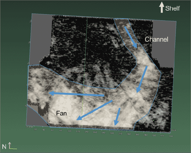
FIGURE 6B
Stratal Slice of Northern Survey
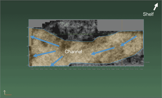
The seismic area in Figure 6A is approximately 40,000 by 30,000 feet in part of the southern area, with the Glasscock Nose slope to the north. In Figure 6B from the northern survey area, the inferred Shelf edge is to the northeast, which is consistent with the location of the Glasscock Nose.
As shown on the left side of Figure 7, four geobodies were identified in the southern survey, representing backfilling channel sands, one on top of the other, deposited as accommodation space became available during sediment deposition. In the Northern survey (right side of Figure 7), one geobody was identified, which is interpreted to be backfilled sand at the base of a channel originating off of the slope around the Glasscock Nose. This interpretation of the geobodies, based on the conditioned post-stack data in both surveys, is consistent with the coherency cube data, our depositional model and existing literature data for the area.
FIGURE 7
Interpreted Geobodies in Southern (Left) and
Northern (Right) Surveys
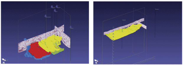
Debris flows and turbidite sediments were sourced from the slope of the Glasscock Nose to the north and northeast of the area, and deposited in accommodation space both in previously existing channels along the slope as channel deposits and along the slope-basin floor transition as basin floor fans.
When evaluating potential assets for purchase or selecting drilling targets, the collection, analysis, integration and interpretation of multiple geological, petrophysical and geophysical datasets provides a better understanding of the subsurface. The results of this integrated approach can be used by engineers, geophysicists, geologists and petrophysicists to better predict production and reserves, and to effectively maximize well placement within an asset by planning, drilling and completing wells in the most efficient manner.
In the Sterling County project, the integrated multidisciplinary study has yielded new insights into the petroleum system within the study area through the understanding of potential eastward lateral and vertical migration of hydrocarbons through permeable debris flows and channels from the basin center into TriGeo Energy’s acreage. The petrophysical analysis and geophysical interpretation also identified prospective porous and brittle facies. This approach has led to a new understanding of the Wolfcamp play’s potential in Sterling County and has led to extending this resource beyond the previously defined eastern limit.
GRAHAM SPENCE is regional technical manager for geology (Americas) for CGG GeoConsulting, which conducted the integrated multidisciplinary evaluation of TriGeo Energy’s Wolfcamp assets in Sterling County, Tx. With 12 years of experience in reservoir characterization, Spence has developed geoscience solutions for both conventional and unconventional reservoirs. He holds a B.S. in geosciences.
AUSTIN S. HEAPE is vice president of H&S Production Inc. and president of TriGeo Energy LLC, an affiliate of H&S Production, which owns and operates a large Wolfcamp position in the eastern Midland Basin. He holds a B.S. in geology from Baylor University and an M.S. in geology from the University of Oklahoma.
ADRIANA PÉREZ is a petroleum geochemist at CGG GeoConsulting Americas. She provides geochemical interpretation for seismic reservoir projects, including integrating seismic reservoir characterization and petroleum system modeling. Pérez has 13 years of experience as a geochemist and petroleum systems analyst. She holds a B.S in chemistry with a major in geochemistry, a specialization in petroleum geochemistry, and an M.S in geology from Central University of Venezuela.
PAOLA FONSECA is a senior petrophysicist in CGG GeoConsulting’s seismic reservoir characterization group, where she provides petrophysical interpretation and rock physics modeling expertise for inversion projects in both conventional and unconventional plays, including the Eagle Ford, Wolfcamp and Haynesville. Fonseca has 12 years of industry experience, and holds a B.S. in petroleum engineering from University of America, Colombia.
ELIZABETH ROLLER is a reservoir geoscientist at CGG GeoConsulting. She previously worked for Hess Corporation and This is Petroleum Systems. Roller has 12 years of experience in exploration and development geology, with expertise in basin modeling, reservoir modeling, seismic reservoir characterization, geochemistry and seismic interpretation. She has worked on conventional and unconventional plays, and holds a B.S. in astronomy-physics from Colgate University and an M.S. in geosciences from The University of Texas at Austin.
CESAR MARIN is a senior geophysical advisor for CGG GeoConsulting, providing innovative solutions for 3-D seismic reservoir characterization using quantitative interpretation techniques. His 15 years of oil and gas experience includes a wide variety of projects associated with unconventional resource plays (Marcellus, Niobrara, Eagle Ford, Haynesville, Bossier and Bakken) as well as the Gulf of Mexico. He holds a B.S. in geophysics from the Central University of Venezuela.
For other great articles about exploration, drilling, completions and production, subscribe to The American Oil & Gas Reporter and bookmark www.aogr.com.