


Geophysics & Seismic
High-Resolution 3-D, Sequence Stratigraphy Delineate New Tight Oil Play
By Lee F. Krystinik and Tony P. Lupo
ARLINGTON, TX.–High-resolution 3-D seismic surveys provide much denser sampling than conventional acquisition designs in terms of both time and space, requiring operators to deploy significantly more recording channels and receivers per seismic array. Although increasing image resolution also leads to a corresponding increase in the complexity of acquisition geometries and costs, the precise detail and richness of high-resolution 3-D data sets are necessary to identify and exploit thin reservoir intervals that are difficult or impossible to image using conventional techniques. Along the same lines, high-resolution 3-D seismic aids in evaluating unconventional reservoirs where natural fracture systems are key to locating higher-permeability “sweet spots.”
Fossil Creek Resources LLC is integrating high-resolution 3-D seismic and detailed sequence stratigraphic analysis to identify Cleveland tight oil sandstone reservoir fairways on the Nemaha Ridge that can be economically drilled using horizontal well bores. The high-resolution 3-D survey utilized novel techniques and processing schemes to significantly reduce data acquisition costs while achieving higher trace counts to enhance imaging accuracy and resolve structural uncertainties such as pinch-outs and faults.
Tight sands in the Upper Pennsylvanian Cleveland formation are an active development target in the Texas and Oklahoma panhandles. However, since drilling started in the 1920s along the Nemaha Ridge of North Central Oklahoma and South Central Kansas, the Cleveland traditionally has been viewed as a shallow (2,500-3,000 feet), thin, tight oil “teaser” or tertiary objective on the way down to more economic objectives such as the Arbuckle, Wilcox and Mississippian Lime.
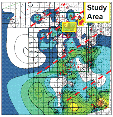
FIGURE 1A
Regional Shearing and Cleveland Deposition and Preservation
Cleveland depositional systems in the Nemaha Ridge area include river-dominated deltas and incised valleys, each with distinctive log and seismic characteristics. Deltaic reservoir successions occur in the upper two-thirds of the Cleveland interval and usually make the best reservoirs.
The deltaic reservoir units are composed of very fine- to fine-grained sanding upward successions exhibiting dip-elongate behavior and rapid changes along strike. Cleveland valleys in the study area are blocky to fining-upward, lower-medium to very fine-grained units that occur in the lower part of the Cleveland succession.
Key Tools In New Play
The optimal drilling locations are best identified by fine-scale correlations and seismic mapping, linked to subtle syn-sedimentary tectonics. High-resolution 3-D seismic (up to 1.4 million traces per square mile) and seismic facies analysis have proven key tools in differentiating and predicting optimal reservoir trends in this new play concept on the Nemaha Ridge, and have created an opportunity for focused horizontal exploitation. This type of analysis is broadly applicable to a number of similar plays in old development areas.
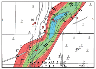
Figure 1A shows the location of the study area as well as the regional shearing that controls Cleveland deposition and preservation. Figure 1B shows the Lower Cleveland valley system (net porosity greater than 10 percent).
FIGURE 1B
Lower Cleveland Valley System (Net Porosity = >10%)
While the Cleveland Sand in western Oklahoma and the eastern Texas Panhandle is deeper (7,000-9,000 feet), thicker (up to 200 feet), and not as porous, operators cannot predict whether their targets are mostly gas with associated natural gas liquids. In the shallower, thinner and more porous portions of the play in North Central Oklahoma and southern Kansas, reserves can be predominantly sweet oil (38-42 degree API gravity) with a number of reservoirs producing enough gas to fuel pumpjacks.
However, some of the technologies and approaches used farther west can apply in the east, as well. Fossil Creek Resources has collected seismic data that are helping delineate reservoir-quality rock for potential horizontal drilling in these Cleveland sands after we prove up our model with two additional vertical wells this summer.
If these vertical wells validate our geological/geophysical model, it would be reasonable and prudent to follow up with horizontal drilling. There are no horizontal wells in the Cleveland in this area. We have established production with the vertical wells, with dry hole costs between $150,000 and $170,000.
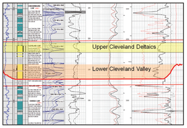
The Cleveland is sandwiched between two carbonate zones: the Kansas City Lime above and the Big Lime below (Figure 2). The deeper Cleveland gas play in the west is separated from the Cleveland oil play in North Central Oklahoma by the Cherokee Reef, a limestone buildup.
FIGURE 2
Upper and Lower Cleveland Log Character
(Lower Cleveland = Incised Valley Fill; Upper Cleveland = River-Dominated Deltaic Lobes)
Initially, we were drilling for the underlying Mississippian and Wilcox trends, but observed strong shows in the Cleveland. We perforated and treated the formation, realizing 30 percent oil cuts, and then decided to complete these zones in three wells that have produced oil hundreds of feet downdip from the main structure, with estimated ultimate recoveries ranging from 10,000 to 30,000 barrels of oil from tight rock in vertical well bores.
Horizontal Potential
Cleveland production can be economical drilling vertically, but the greater potential is in using seismic to identify reservoir-quality rock and then drill horizontally to maximize the bore hole’s exposure to the pay zone area (thereby, increasing the volume of reserves that can be recovered per well). The zones are very heterogeneous, but by drilling the Cleveland horizontally rather than vertically, we potentially can break through many baffles and small internal barriers that may separate and compartmentalize reservoirs.
In western Oklahoma and the eastern Texas Panhandle, where laterals are 4,000 feet and longer at times, we see tight valley facies with the best porosity and best gas liquids production. But farther east, the best porosity development and best oil cuts are in the upper river-dominated deltaic section.
We have completed the high-resolution seismic survey over North Braman Field, located in Kay County, Ok., which borders Sumner County, Ks. Historically, wells in North Braman Field have produced almost 30 million barrels of oil primarily out of four zones, including the Wilcox, which is still producing oil today and has single wells that routinely can recover 100,000 barrels of oil.
The depth and thickness of the Cleveland in North Braman Field are half those farther west, with formation thickness typically less than 100 feet. The portion of the Cleveland we are exploiting has 14-16 percent porosity compared with 8-12 percent for the play in western Oklahoma.
Initial Vertical Well Results
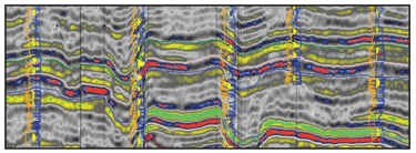
Fossil Creek Resources drilled five vertical wells last summer and established production from three of those in the Cleveland. A well-log structural cross-section in Figure 3A shows the draping of Cleveland stratigraphy over the North Braman structure. The seismic section in Figure 3B follows the same line as the well log cross-section, and shows the nature of the structure draped by the Lower and Upper Cleveland sands on the northern plunge of the North Braman structure. Note the strong amplitude anomalies associated with thick, porous sand development and the lack of response to thin sand development.
FIGURE 3A
Well Log Cross-Section of North Braman Structure
Out of three completed wells in the Cleveland, two continue to produce. Initial production rates on these wells ranged from 40 to 50 barrels a day, flattening out to 10-15 barrels of oil a day with 25-30 percent oil cuts. The State No. 15-3 is averaging 15 barrels of oil and 40 barrels of water after a year on production.
FIGURE 3B
Seismic Section of North Braman Structure
The State No. 16-2 well was drilled for a deeper objective and penetrated the Cleveland 100-150 feet downdip from the other two wells and only produced three to five barrels of oil a day and 100 barrels of water. However, we were surprised that oil was present at all. Right now, we are trucking the produced water out, which hurts economics, but water disposal will allow enhanced economics and ultimate recoveries in high-water-cut wells.
Better wells may be realized near structures, but not necessarily on top of structures, because the Cleveland typically thins or pinches out onto older structures where there is nondeposition or erosion. We believe the play can be extended much further downdip and be similar to an oil resource play as long as water can be disposed into the Arbuckle through injection wells. For example, we could likely triple volumes in the State 16-2 and produce 9-15 barrels of oil a day and move 300 barrels of water.
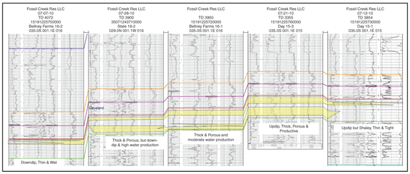
FIGURE 4
Example Vertical (Left) and Horizontal (Right) Cleveland Wells
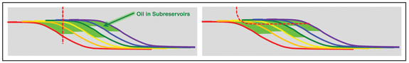
But drilling horizontally could increase the recovery factor by two to four times compared with the recoveries experienced from vertical wells (Figure 4). Instead of having a Cleveland well with a estimated ultimate recovery of 20,000-25,000 barrels of oil, horizontal drilling could increase average EURs to the 100,000-barrel range out of a well with a vertical depth of 3,500 feet and a 1,600-foot lateral. One vertical Cleveland well on our survey drilled in the 1960s has produced 90,000 barrels of oil.
High-Resolution 3-D Data
To begin identifying targets, we developed a low-cost, high-resolution 3-D survey by exploring novel acquisition techniques and processing schemes. We were able to collect significantly better seismic data by reducing the bin size to 55 feet, putting more traces per square mile and resolving lateral changes more robustly, including pinch outs, channel edges and faults. The final cost of the high-resolution data set averaged $25,000 per square mile.
When we saw changes in amplitude and frequency within the Cleveland interval, our first concern was whether we were actually seeing changes in thickness or porosity in the units above it and below it. But isopachs and isochrons revealed that the Kansas City and Big Lime carbonates do not vary laterally within the survey area. Because we do not see huge pods of porosity develop or rapid thinning and thickening, the observed amplitude changes are caused strictly by changes in the amount of good-quality reservoir sand in the Cleveland.
Log data from wells in the river-dominated deltaic portion of the play indicate porosities as high as 18 percent in the upper Cleveland, with an average porosity of 14-16 percent (obviously, very good for a “low-permeability” tight sandstone). Porosities in the lower Cleveland valley-fill sands range between 10 and 14 percent. The upper and lower segments of the Cleveland have average thicknesses of 20 to 40 feet each.
We can use both frequency- and amplitude-derived attributes from the seismic to map reservoir quality in the Cleveland. The presence of thicker, high-quality Cleveland, either upper or lower within the interval, creates a “blooming” of the amplitude and a reduction in frequency content. This is significant because it is often difficult to detect thin, porous reservoirs in the hard, fast rock common to the Mid-Continent, especially in areas where the maximum interval thicknesses approach 100 feet or less.
Attribute Analysis
Attributes can be generated from the seismic data to map and predict where changes occur throughout the entire volume, so that determination does not have to be made using well control alone. A series of seismic attributes were generated that respond well to the lateral thickness and porosity changes observed in the Cleveland reservoirs. This involved creating a geophysical model based on sonic and density well log responses. The modeling analysis was initiated to make sure that what we saw in the seismic sections was “real” and to back check them against the modeling and actual penetrations.
FIGURE 5
Cross-Plot of Upper/Lower Cleveland Net Sand versus Attribute Values From Key Wells in 3-D Survey Area
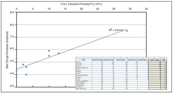
Using minimum trough envelope amplitude, an attribute map was created for the Cleveland. Those values were then cross-plotted for all of the wells penetrating the Cleveland within that area, which includes about six square miles. The net sand, which is sand greater than 10 percent porosity, was then cross-plotted on top of that information.
Minimum trough amplitude does not bloom with net sand values of five feet or less and exhibit maximum trough envelope amplitude of 4.0-5.0. Another group of wells with between 10 and 15 feet of net sand has a slightly brighter amplitude response. Our best well had almost 35 feet of net porous sand and a much stronger amplitude response.
When a line is drawn for that amplitude-pore volume plot (Figure 5), a strong statistical relationship emerges between the values of maximum trough amplitude and the amount of net porous sand in the system. An R-squared correlation greater than 0.6 is pretty good for geological data, so what we observed here is a very positive correlation. The equations for that line were used to generate a map that is being used to guide drilling decisions.
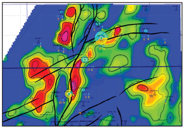
FIGURE 6A
Maximum Trough Envelope Amplitude Map
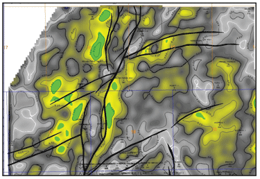
Figure 6A shows a maximum trough envelope amplitude map from the Cleveland interval, illuminating areal distribution of net sand (greater than 10 percent porosity). Figure 6B shows a pseudo pore-feet map established from the relationship between maximum trough amplitude and net sand attributes. Blue in the pie diagrams at the well spots represents the thickness of net sand greater than 10 percent in the upper Cleveland, while yellow represents net sand greater than 10 percent porosity in the lower Cleveland.
For example, the strong anomaly is quite apparent at the Day No. 15-3 (denoted by the large circle in the upper center of the map). The well encountered 20 feet of net sand in the upper Cleveland and a little more than 10 feet of sand in the lower Cleveland. To the south, the bubble with primary contribution at the Bellney Farms No. 16-1 is a porous sand about 10 feet thick in the upper Cleveland. Farther down, another bubble is mostly yellow at the State No. 16-2 because it produces primarily from the lower Cleveland sand.
FIGURE 6B
Pore-Feet Map Generated from Net Sand/Maximum Trough Envelope Amplitude
The geophysical model predicts a roughly north-to-south sand fairway with a good accumulation of porous sand. Penetration data show that the model predicted sand robustly for all wells where we had good net sand and blooming amplitude, or where there was not much quality reservoir sand and amplitude did not bloom at all.
So, we now had a geophysical model that appeared to link directly to geological changes in thickness, and most importantly, porosity. We believed we could predict the key reservoir parameters required to reduce risk in the Cleveland by detecting porosity and also indicating where the rock was tight. The next step is to use a higher-order analysis to predict whether porous sand exists in the upper or lower Cleveland, or both. To that end, we are using a commercial Windows®-based seismic attribute analysis software program that identifies patterns in a series of attributes associated with frequency and amplitude. It is our job to interpret the trends. We have seen two strong distributions of seismic facies. The facies analysis did a good job of predicting where we have the thickest amount of upper Cleveland presence, and the goal of the analytical work we are performing is to pick apart these two systems so they can be mapped independently. This should enhance the predicted reservoir maps and optimize our anticipated plan of depletion.
We will be excited to see how the program works, because the techniques applied in a small way at North Braman may have opened a new play opportunity within a heavily drilled, old area. With fit-for-purpose, high-resolution 3-D analysis, carefully integrated with detailed subsurface work, old basins really can show us that they still have new tricks.
LEE F. KRYSTINIK is a principal with Fossil Creek Resources LLC in Arlington, Tx. He has 30 years of experience specialized in applied sedimentary and stratigraphic analysis to predict clastic reservoirs. In 2006, Krystinik formed Fossil Creek Resources, an independent exploration company that uses new technologies in the search for overlooked oil targets. He has held positions as manager of geology at Union Pacific Resources and global chief geologist for ConocoPhillips. His areas of interest include syntectonic sedimentation and other controls on basin-fill architecture, integrated play assessment and cost effective implementation of new concepts and technology. Krystinik is a past president of the Society for Sedimentary Geology and a former American Association of Petroleum Geologists distinguished lecturer in North and South America, has won a number of awards for achievements in petroleum geoscience. He holds a B.S. in geology from the University of Texas at Arlington and an M.S. and a Ph.D. in geology from Princeton University.
TONY P. LUPO is vice president of geophysics at Fossil Creek Resources LLC in Arlington, Tx. He has 11 years of oil and gas industry experience, and prior to joining Fossil Creek Resources, he helped establish enhanced acquisition and interpretation technologies used by Samson Resources’ Mid-Continent division for various deep gas plays that were a significant component of its portfolio. Lupo began his career at ConocoPhillips, working with various asset teams, including West Africa, the Gulf of Mexico, Alaska and the Mid-Continent. As part of ConocoPhillips’ integrated geologic analysis group, he focused on interpretation, rock physics, high-resolution seismic acquisition and processing, particularly in the Mid-Continent, where his efforts significantly reduced risk in key stratigraphic plays and were used to help identify several previously undocumented plays. Lupo holds a B.S. in geology from Grand Valley State University and an M.S. in geophysics from New Mexico Tech.
For other great articles about exploration, drilling, completions and production, subscribe to The American Oil & Gas Reporter and bookmark www.aogr.com.