


Global Opportunities
New, Long-Offset 2-D Data Illuminate Exploration Potential In Offshore Croatian Adriatic
By Barbara Doric, Neil Hodgson and Richard Wrigley
ZAGREB, CROATIA–Offshore Croatia is a proven, yet underexplored hydrocarbon province with both oil and gas potential lying at the heart of Europe’s hungry energy market.
The Croatian offshore area spans more than 22,000 square miles, and in the northern one-third of the area, 17 gas discoveries have been made with recoverable reserves of 1.4 trillion cubic feet (241 million barrels of oil equivalent). Three of these shallow, clastic offshore fields are on production, accounting for 1.6 percent of Europe’s offshore natural gas production.
However, despite this success, only 116 wells have been drilled in the Croatian part of the Adriatic Sea, and much of the oil-prone central and southern area is virtually unexplored.
Seeking to encourage international investment in the oil and gas sector–particularly offshore–the Croatian government enacted a series of reforms in 2013, including updating the nation’s hydrocarbons laws, establishing new legal and fiscal terms, and forming a dedicated agency (the Croatian Hydrocarbon Agency) to oversee oil and gas activities.
With these key milestones accomplished, and with Croatia becoming a member of the European Union in 2013 (enhancing stability and investment security for companies coming into the country), the government officially opened Croatia’s inaugural offshore licensing round on April 2. After three decades of virtually no offshore exploration drilling, the tide has turned.
The ongoing licensing round marks the first time the country has formally opened its maritime borders to international exploration companies, and underscores Croatia’s commitment to embracing a new phase in developing its oil and gas resources. An extensive benchmarking evaluation process undertaken in 2013-14 ensures the new fiscal and legal terms governing the blocks are very competitive from both a regional and a global perspective.
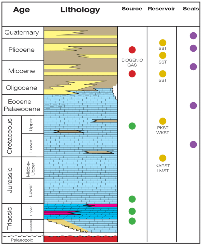
The initial round includes 29 offshore blocks ranging in size from 1,000 to 1,600 square kilometers in water depths from less than 50 to more than 1,300 meters. Figure 1 shows the stratigraphy and play elements offshore Croatia.
FIGURE 1
Offshore Stratigraphy and Play Elements
Hydrocarbon exploration offshore Croatia commenced in 1970 with the Jadran No. 1 well, followed in 1973 by the Jadran No. 6 well, which made the country’s first offshore gas discovery at the Ivana Field in the shallow gas play of the northern area. Lying close to the mouth of the current-day Po River, these reservoirs are Pliocene clastic deltaics.
In the central and southern parts of the Adriatic, exploration activity has focused historically on a Cretaceous carbonate platform oil play. On the Italian flank of the basin, this carbonate platform and platform margin play system has been targeted successfully with the discovery of the Rospo Mare, Elsa, Ombrina Mare, Aquila, Rovesti and Giove fields. Although dramatically less explored on the Croatian side, several wells have encountered oil shows in the Cretaceous. Indeed, oil has been recovered from deeper targets on that margin, proving a working hydrocarbon system exists. No commercial discoveries have been announced to date, however.
To address this lack of success, in 2013 the Croatian authorities sought to resolve the primary difficulty with historical exploration offshore Croatia: a lack of high-quality seismic required to successfully delineate platform margin plays.
High-Quality Seismic
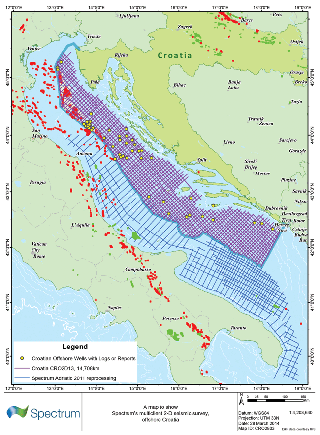
Seismic is the key tool required to identify the presence of a platform margin and subtle reef/slope/basin floor fan seismic facies, and the poor quality of historical seismic on this margin led to a series of poorly located exploration wells. To address the lack of high-quality seismic hampering exploration offshore Croatia, 14,700 kilometers of 2-D, multiclient seismic data were acquired in 2013-14 (Figure 2). The long-offset, high-fold 2-D seismic data were acquired with an 8,100-meter cable on a 5 x 5-kilometer grid. This new dataset subsequently has been tied to an 8,000-kilometer 2-D dataset over the Italian margin that had been reprocessed in 2011.
FIGURE 2
Offshore Croatia 2-D Multiclient Acquisition Area
Not only can this new dataset reveal the broad structure of the entire Adriatic, the high quality of the data allows the imaging of deep, Upper Triassic source-rock-bearing basins that had been unseen previously. This is crucial for exploration hydrocarbon system modeling, enabling oil and gas exploration companies to assess the basin’s hydrocarbon potential for the first time. Multiple carbonate platforms can be imaged and mapped accurately, leading to the identification of high-porosity/permeability play systems, particularly around platform carbonate margins.
Despite lying between the dramatic thrust belts of onshore Croatia (the Dinaric thrust belt), and Italy (the Apulian thrust belt), the surprising simplicity of basin structure is revealed to be dominated more by halokinetic (salt movement) tectonics, forming large, simple traps that have the potential for sizable oil discoveries.
An initial study of the new datasets across the Adriatic margin has led to the startling realization that although the Mesozoic (carbonate) and Cenozoic (clastic) play systems offshore Croatia are similar to those on the Italian margin, the seismic data indicate that the Croatian offshore has a superior hydrocarbon system, given the asymmetry of the Adriatic caused by the timing of opposing thrust systems, and most importantly, increased halite presence below the Mesozoic carbonates in the east.
Regional Geology
The oldest sequences penetrated by wells offshore Croatia are Triassic evaporates. Within the Adriatic margin, these are predominantly anhydritic to the west and halites to the east. The recognition and understanding of mobile halite distribution in the east reveals the controls on the structural development of the overlying carbonate platforms both onshore and offshore Croatia.
Well information, outcrop studies onshore, gravity and magnetic studies, and the new 2-D data have confirmed the presence of a thick Triassic syn-rift sequence composed of halite, dolomites, sabkha carbonates and black organic-rich shales. These latter sediments–deposited as thick, algal mats in the sabkha environment both in Late Triassic syn-rift grabens and within halokinetically controlled rafts–are the dominant source rock for the region.
The Upper Triassic (Burrano formation) is the key source for the multibillion-barrel oil fields of the Monte-Alpi, Cerro Falcone, etc., Apulian thrust belt trend onshore Italy, and is responsible for much of the oil onshore to the east in Croatia and the Pannonian Basin. Both onshore Italy and Croatia, the many seeps have been typed to a Late Triassic source rock, which itself is exposed in many places.
Offshore Croatia, it will be the ability to map the Triassic mini-basins and model the generation and migration pathways that will unlock the oil potential of this margin. Such oil was recovered from Late Triassic carbonates in the deepest well drilled to date offshore Croatia (Vlasta-1). However, source basins and migration pathways have been elusive with legacy seismic data, since the key reflectors were largely not imaged.
On the Italian margin, the Triassic evaporates are largely anhydritic. However, on the eastern margin, Triassic halite loading by Mesozoic carbonate platform deposition created large diapiric structures that dominate Central Adriatic prospectivity. Some of these salt diapirs are imaged penetrating the seabed. Such features extending above the density equilibration level must be connected to a deeper halofer, and it is reasonable to envisage thick salt facilitating the decollement of Dinaric thrusts.
The heterogeneities of the Triassic salt sequence not only determined the structural fabric of the region, but provided the palimpsest controlling the subsequent Mesozoic deposition. This provides the dominant prospectivity of the Croatian margin, and Jurassic and Cretaceous platform carbonate margin deposits.
Thick Carbonate Platforms
During the Jurassic and Cretaceous, the Adriatic Basin comprised a wide, shallow-water carbonate shelf, distal from any clastic input from the Late Triassic until the Eocene. Steady subsidence of the margin resulting from the accumulation of thick carbonate platforms persisted, largely unbroken for close to 130 million years. That persistence was perfect for developing platform-margin facies at the edges of localized basins on the shelf associated with deep-seated rifts. [image_
These are interesting for explorers, since they often are sites of higher-energy deposition, with reef buildups on the shelf margin, and accumulation of porosity-retaining talus debris sloping down the often steep slopes leading off the margins into the deeper basins. In places, reworked carbonate-storm deposits were deposited along the base of the platform margin slope in the form of carbonate-turbidity deposits.
At the end of the Eocene, the collision of the northern margin of the carbonate platform with the European mainland created the Po Valley, which began to drain the Southern Alps and deposit clastic sediments into the Adriatic. These clastics largely killed off the carbonate margins, and subsequent deposition is dominated by clastics derived from the Po.
FIGURE 3
Four Structural Development Stages
Of the Croatian Adriatic Margin
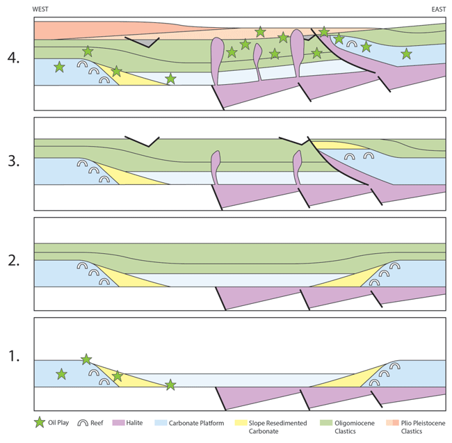
In the Oligocene, the continued collision created the west-verging Dinaric thrust belt (similar to that in the Ionian Basin to the south). This loaded the eastern part of the Adriatic, developing an Oligo-Miocene foredeep that captured the first sediments from the Po Valley. Subsequently in the Pliocene, the east-verging Apulian thrusting to the west formed a similar foredeep in the northwest, which has captured the more recent deposits of the Po, providing the reservoirs for the northern, shallow clastic gas play.
A clear and easily mapped unconformity (the Messinian Unconformity) separates the Oligo-Miocene sequence from the Plio-Pleistocene. There is truncation in places at this unconformity, generated by halokinetic structuration. The Messinian unconformity appears often in wells below a thin anhydrite layer that likely was deposited during the post-Messinian marine transgression. Halokinesis continued during the Tertiary, creating diapir traps for turbidite and delta top sediments during the Plio-Pleistocene.
Figure 3 shows a simplified model for the structural development of the Adriatic Basin in four stages, illustrating the main hydrocarbon play concepts: Mesozoic carbonate platforms (1), Oligo-Miocene foredeep clastics (2), late Miocene Dinaric thrusting and halokinesis (3), and Plio-Pleistocene clastic delta loading and late charge (4).
Hydrocarbon Play Systems
In addition to the newly acquired 2-D seismic data, new gravity and magnetic data, and the adjacent rock outcrop “laboratory” onshore Italy and in the Croatian Dalmatian Islands and Dinaride thrust belt, Croatian authorities have taken great pains to make all of the exploration well data from every well offshore Croatia available for the ongoing license round. In addition to providing the velocity data that allow well stratigraphy to be tied to seismic, this also is key for facies and lithology evaluation across the basin. Well data, outcrop data and high-quality seismic data allow the key risk elements in hydrocarbon play analysis to be addressed.
A key exploration risk element that can be significantly constrained and reduced for plays in this basin is the distribution and maturity history of the Triassic source rock offshore Croatia. The long record length of the regional 2-D seismic allows deep Triassic reflector(s) to be imaged to map the distribution and burial depth of Late Triassic source rock. These reflectors are the first acoustic impedance contrasts below the largely homogeneous lithology of the Mesozoic platform carbonates, and may indeed represent low-velocity, mature source rock reflectors. Layer cake depth conversion, prestack depth migration and well data confirm that the Triassic has been buried to depths between five and seven kilometers over much of the Croatian offshore.
In many basins, the deep burial of the source rock might be a significant problem, leading to an overmature, depleted source. However, in the Adriatic, the relatively low geothermal gradient recorded in offshore wells (18-22 degrees Celsius per kilometer) drilled in the Croatian Adriatic indicate that the Triassic source rocks are likely to still be within the oil and gas generation windows. Mapping the individual source basins and carefully reconstructing the seismic data reveal numerous deep, pre-Messinian structures and traps that could have captured early charge sealed by thick Plio-Pleistocene deltaic mudstones.
FIGURE 4
Bouguer Gravity and Basins Map
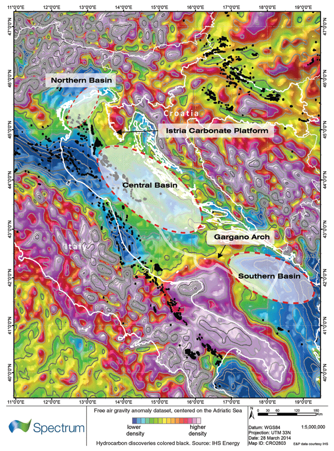
FIGURE 5
Central and Southern Basin Strike Line
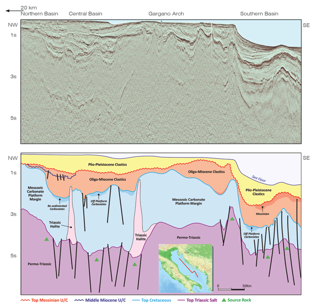
The 2-D seismic confirms regional gravity data (Figure 4) indicating the presence of three basins offshore Croatia: northern, central and southern. Each basin has distinct characteristics and hydrocarbon play types. These can be seen on the northwest-to-southeast trending strike line running centrally down the Adriatic (Figure 5).
New Level Of Detail
The clear imaging of the new seismic dataset details events and sequences down to 8.0 seconds of two-way travel (TWT) time, providing a level of detail previously not seen, and leading to a better understanding of Mesozoic/Cenozoic basin histories and tectonic controls on prospectivity.
The northern basin extends southeast from the Po Depression to the Istria Platform. It is defined by a thick Plio-Pleistocene sequence (the Apulian thrust foredeep) onlapping onto a deformed Oligo-Miocene foredeep section and Mesozoic carbonate platform/platform margin sequence below the Messinian unconformity. In Italian waters, the deformation in the Mesozoic section is dominated by salt walls and diapirs that have been compressed by Apulian thrusting. In Croatia, the sub-Messinian unconformity comprises Oligo-Miocene foredeep.
FIGURE 6
Northern Basin Dip Line
The Plio-Pleistocene clastics strongly onlap the Messinian unconformity, such that this unit is remarkably thin, or absent in the east against the coast of Croatia. Ponded stacked turbidites and pro-delta clastics provide the reservoir for the Croatian gas fields. The Cenozoic basin fill extends to below 2.0 seconds TWT in the deeper parts of the basin and the gas fields, and discoveries are associated with strong “soft kicks” with amplitude and amplitude-variation-with-offset anomalies (Figure 6).
The central basin, which is bounded by the Istria carbonate platform to the northwest and the Gargano Arch to the southeast, is less asymmetric than the northern basin, with the Italian margin less loaded by the Apulian foredeep. The basin on the east side of this line represents the Oligocene foredeep to the Dinarides. The deepest reflectivity at 6.0 seconds TWT is close to (and may reflect) Triassic source rock.
Several wells in the basin have encountered oil in Cretaceous and Triassic reservoirs, in addition to gas and oil shows in the Oligo-Miocene. Jurassic and Cretaceous carbonate sequence depositional facies can be readily interpreted on the 2013-14 2-D data, presenting the opportunity to delineate the platform margin in this structurally complex area to reveal new plays and previously unimaged traps. Identifying the true carbonate platform margin, and the plays associated with it, is the key to finding porosity in this margin, which when tied to the oil migration studies, will reveal a new suite of oil plays for explorers to chase.
The deeper-water southern basin is located south of the Gargano Arch and is notably different in character to the northern and central basins, reflecting the basin fill. The southern basin extends through Montenegro into the Ionian Basin and includes the petroleum province offshore Albania. The Mesozoic carbonate platform margin is clearly distinguished by changes in seismic facies and the thickness of the Triassic to the top of the Cretaceous interval across this margin. Oligo-Miocene and Plio-Pleistocene stratigraphic plays also are interpreted in the southern basin on-lapping deeper structures. The Messinian unit is a characteristically strong reflector and may represent a clastic play south of the Gargano Arch.
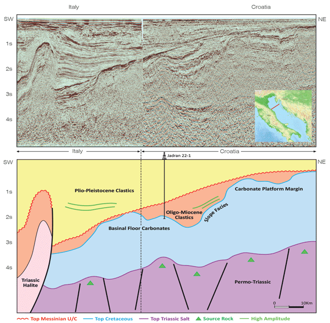
A cross-Adriatic dip line of the Italian and Croatian platform margins clarifies the hydrocarbon system proven by drilling offshore Italy. Shallow, small structures close to the Italian mainland are fed by hydrocarbons generated in the deep Croatian basin to the east. However, what is perhaps most striking are the relative simplicity of the hydrocarbon system and the lack of complexity from Dinaric compression. This suggests that the southern basin has high potential for large, high-value traps.
High-quality seismic data permit the hydrocarbon potential of the underexplored Croatian Adriatic to be assessed for the first time. The dataset images deep, source-rock-bearing basins as well as multiple carbonate platforms. Combined with a new regulatory/fiscal structure and the ongoing licensing round, the insights gleaned from the regional 2-D data are helping unlock the imminent potential to develop the Croatian offshore into a much more significant hydrocarbon province over the next few years.
BARBARA DORIC is chief executive officer of the Croatian Hydrocarbon Agency in Zagreb. Established this year, the CHA participates in all activities related to tender procedure and issuing exploitation permits, monitors the fulfillment of investor contractual obligations, and collects and prepares information for presentation to potential investors in the Croatian oil and gas sector. Before helping establish the CHA, Doric served at another government institution and played a key role in developing the regulatory framework for Croatia’s first offshore exploration and production licensing round. Prior to that, Doric was a senior consultant responsible for the Southeast European energy sector at a management consulting company.
NEIL HODGSON is geoscience director at Spectrum. He joined the company in 2012 after a 25-year career in exploration geology roles at BP, BG, Premier Oil and Matra Petroleum. Hodgson manages Spectrum’s geology, geophysics and GIS technology team in the U.K. office, and is focused on finding good hydrocarbon stories behind Spectrum’s 1.5 million-kilometer 2-D seismic library, and acquiring new data worldwide.
RICHARD WRIGLEY is the lead geoscientist at Spectrum, working on the Croatian 2-D seismic acquisition project. Following a successful 25-year career in oil and gas exploration with Britoil, BP and BG, he has worked with Spectrum in its U.K. office for the past year.
For other great articles about exploration, drilling, completions and production, subscribe to The American Oil & Gas Reporter and bookmark www.aogr.com.