


Integrated Site Investigation Guides Development Plans At Deepwater Shenzi Field
By Shawn Williamson, Nektaria Zois, and Antony Hewitt
HOUSTON–Seafloor features and associated fauna present significant challenges to site selection for the wells, moorings, subsea equipment and flowlines associated with developing deepwater fields. At the Shenzi Field, these challenges were overcome through a proactive approach that addressed deepwater marine biology using a series of site investigations that began during initial planning phases of field development work.
The continental slope of the deepwater Gulf of Mexico is characterized by complex seafloor topography, caused in part by shallow salt deformation. Locally, faults provide pathways for hydrocarbon migration through the suprasalt sediments to the seabed, and these seafloor hydrocarbon seeps can provide habitat for unique biologic communities. The integrated site investigation at Shenzi utilized an autonomous underwater vehicle, high-resolution geophysical survey; a piston coring geotechnical program; and a remotely operated vehicle video survey to develop a successful plan from both engineering design and regulatory permitting perspectives for developing the field in an environmentally responsible manner.
Operated by BHP Billiton Petroleum (44 percent interest) with joint venture partners Amerada Hess and Repsol (28 percent interest each), the field was discovered in 2002. It is located on the continental slope approximately five miles north of the Sigsbee Escarpment in Green Canyon Blocks 609, 610, 653 and 654. Water depths range from 4,150 feet in the northeast quadrant of Block 653 to 4,480 feet in the southeast corner of Block 654.
After drilling the Green Canyon 654 No. 1 discovery well, six appraisal wells were drilled to confirm the field’s commerciality. The field development concept for the initial phase of production consists of multiple subsea wells around three drill centers tied back to a dedicated tension leg platform processing facility through production flowlines, gas lift/injection flowlines and umbilicals. Third-party oil and gas export pipelines transport production from the Shenzi TLP to market.
Site Investigations
A shallow hazards desktop study was conducted during the concept phase of the Shenzi project to identify seafloor and shallow geologic features pertinent to field development. This study was based principally on a spectrally enhanced 3-D seismic data volume, shallow hazard reports submitted in support of exploration plans for well locations, and other readily available data.
Numerous fault scarps were evident from seafloor renderings derived from the Shenzi 3-D seismic volume. A zone of seafloor faults was apparent above a shallow salt ridge that extended from the northeast quadrant of Block 653 across the southern boundary of Block 610. An area of hummocky topography was apparent adjacent to fault scarps near the boundary between blocks 653 and 654. A few isolated areas indicative of possible hydrocarbon seeps were identified from a seafloor amplitude rendering generated from the 3-D data.
The desktop study results were considered when devising preliminary field layout options. However, the inherent resolution limitations of 3-D seismic data inhibited the characterization of conditions to the level of detail required for engineering design and regulatory permitting of facilities. Therefore, the desktop study also identified additional site investigations that were needed along with budgetary cost estimates and timelines for completing the subsequent studies.
In addition to the recommended site investigations using the AUV high-resolution geophysical survey, piston coring and ROV video survey, soil boring programs were conducted to measure the geotechnical parameters necessary for foundation design of both the TLP and the subsea equipment.
AUV survey
An extensive AUV survey was acquired in spring 2005 during the early prefeasibility phase of the Shenzi project. The AUV collected high-quality, multibeam swath bathymetry with backscatter, side-scan sonar and sub-bottom profiler data. The survey was designed to provide full-swath bathymetry and side-scan sonar coverage of the seafloor across a 73 square-mile area that encompassed the maximum anticipated extent of the field layout.
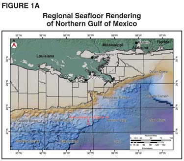
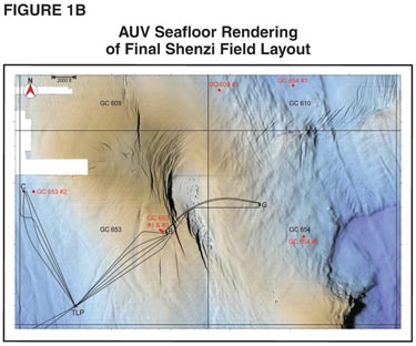
Figure 1A is a regional seafloor rendering of the Northern Gulf of Mexico with the Shenzi Field location (as shown in Figure 1B) highlighted. In Figure 1B, the final Shenzi Field layout is superimposed on a seafloor rendering generated from the AUV swath bathymetry data. The AUV data revealed numerous closely spaced fault scarps within the zone of seafloor faults previously recognized from the 3-D seismic data in the eastern portion of Block 653. In the flowline corridor between drill centers “B” and “G,” fault scarps ranged from less than one to 20 feet high, with seafloor gradients locally exceeding 30 degrees.
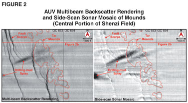
The AUV data also resolved clusters of seafloor mounds adjacent to this fault zone in the area of hummocky seafloor topography previously evident from the 3-D seismic data. Individual mounds were circular in shape and generally less than five feet high. These mounds exhibited a light, low-reflectivity response on the multibeam backscatter rendering and side-scan sonar mosaic (Figure 2).
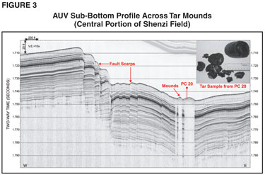
The sub-bottom profiler signal was completely attenuated in the acoustic “wipeout” zone that extended from the seafloor to the limit of sub-bottom penetration directly beneath each mound (Figure 3). High-amplitude seafloor response and acoustic wipeout often are associated with authigenic carbonate rock outcrops and gas-charged sediments related to hydrocarbon seepage. However, these mounds did not exhibit the high-reflectivity seafloor response characteristic of hydrocarbon seeps.
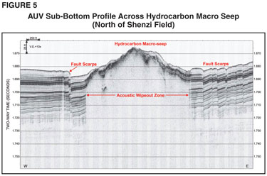
A dark, high-reflectivity area was identified on the multibeam backscatter rendering and side-scan sonar mosaic near the northern limit of the AUV survey (Figure 4). This area also was associated with seafloor faults and underlain by an acoustic wipeout zone (Figure 5). The top of the acoustic wipeout zone was marked by high-amplitude reflectors a few feet below the seafloor, indicative of gas-charged sediments.
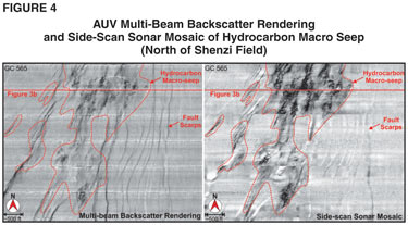
Based on geophysical character, this area was interpreted to be a hydrocarbon macro seep that could support a high-density chemosynthetic community. However, this interpretation was not visually confirmed because this area and other potential chemosynthetic community sites delineated from the Shenzi AUV survey were avoided when designing the field layout.
Coring Program
Once the preliminary field layout was revised based on the AUV survey results, a piston and box coring program was designed to measure soil properties along the proposed in-field flowline routes. In addition, several supplemental piston core sites were chosen to sample representative fault scarps and mounds in the vicinity of the proposed flowlines between drill centers B and G.
According to Minerals Management Service Notice to Lessees No. 2000-G20, addressing deepwater chemosynthetic communities, seafloor disturbance must be avoided within 250 feet of features that could support high-density chemosynthetic communities. Since it was uncertain whether chemosynthetic organisms were associated with the mounds near Shenzi’s preliminary flowline routes, a request was submitted to MMS seeking permission to acquire piston core samples from several mounds. Permission was granted, since coring was not considered to pose significant impact to any chemosynthetic organisms that might be present.
The piston coring field investigation was conducted in June 2005 near the completion of the prefeasibility phase of the Shenzi project. A total of 47 piston cores and 11 box cores were acquired during the program. An ultrashort base line (USBL) positioning system was used to accurately target the fault scarps and mounds. The piston core barrels were 20 feet long and typically achieved full penetration with an average recovery of 16 feet. However, the cores that targeted mounds had minimal penetration and recovered plugs of solid tar.
Laboratory testing confirmed that shallow soil conditions were consistent across the field away from the tar mounds. The soils typically consisted of very soft, high-plasticity clay with a shear strength profile that generally increased with depth.
Age-dating analyses were performed on select piston cores that sampled a complete section of the shallow stratigraphy. The age of marker horizons was constrained in the Shenzi Field for the purpose of fault displacement computations. This analysis indicated that future activity along faults crossed by the Shenzi flowlines between drill centers B and G would likely follow a gradual growth trend with a seafloor displacement rate of less than 0.04 inches a year.
ROV Survey
The ROV video survey was acquired in July 2005 during the early feasibility phase of the Shenzi project to screen the flowline corridor that crossed faults and mounds between drill centers B and G. The ROV was equipped with USBL positioning and navigation video overlay. In addition, specially designed six-foot push core barrels were fabricated and mounted to the ROV cage. The ROV recorded high-quality color video and acquired nine push cores along five track lines that traversed 3.1 nautical miles during two survey phases.
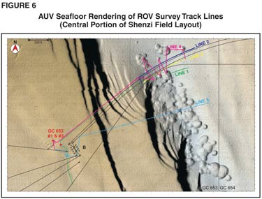
During the initial phase of the survey, line one was acquired along the centerline of a preliminary flowline route that crossed the fault scarps and mounds (Figure 6). There was no evidence of seafloor instability along the fault scarps and only the largest scarps imaged by the AUV data were visible as gentle seabed undulations. When the ROV traversed the area where the AUV data had imaged mounds, numerous small tar pillows were observed (Figure 7A). No evidence of active hydrocarbon seepage was seen and no chemosynthetic organisms were observed.
While asphalt flows have been identified in the Campeche Knolls in the southern Gulf of Mexico, the tar mounds observed by the ROV at Shenzi Field are believed to be one of the first documented occurrences of seabed asphalt in the northern Gulf of Mexico region.
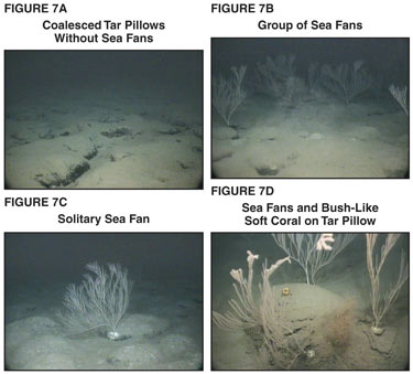
The most abundant organisms observed on the tar mounds were deepwater sea fans (Figures 7B and 7C), but a bush-like soft coral was also seen (Figure 7D). While most of the sea fans were attached to tar pillows, not every tar pillow harbored a sea fan. No sea fans were observed on the soft muddy bottom that characterized most of the field layout away from the tar mounds.
After completing line one, the ROV vessel departed the Shenzi Field to assist a drill rig in preparing for an approaching storm. In the meantime, the ROV video was transported to shore along with the push core samples taken during the first phase.
The video was reviewed with a marine biologist specializing in deepwater Gulf of Mexico benthos (seafloor organisms and habitats). The marine biologist confirmed that the sea fans were not chemosynthetic organisms, but were a type of soft coral that attached to the tar mounds because they provided hard substrate. It was postulated that the sea fans were feeding on nutrients suspended in the water column and transported by bottom currents, which have been independently observed by ROV-mounted current meters during drilling operations at Shenzi.
During the hiatus in survey operations, a conference call was held with MMS biologists to inform them of the preliminary ROV survey results. Since the sea fan species could not be identified from ROV video alone, an opportunity to recover a sea fan specimen was discussed with MMS. The MMS biologists recognized the scientific value of this opportunity and encouraged the acquisition of a specimen.
The scope of work was revised for the second phase of the ROV survey to include centerlines for two modified flowline routes (lines two and three), a zigzag line across the apparently featureless corridor between the tar mounds (line four), and an alternate flowline route (line five) directly between drill centers B and G. Also, additional push core samples were planned as well as an attempt to obtain a sea fan specimen.
Similar to the first phase, no evidence of active hydrocarbon seepage was seen and no chemosynthetic organisms were observed during the second ROV survey phase. There was excellent correlation between the ROV video and geophysical data, as tar pillows were only observed within the mounded areas imaged by the AUV. Furthermore, sea fans were seen only where the tar pillows were present. An intact sea fan specimen was recovered at the end of the ROV survey.
Comprehensive Report
Results from the site investigations were integrated into a comprehensive engineering/geological assessment report that documented seafloor and shallow geologic conditions pertinent to developing the Shenzi Field. This report was based principally on interpretations of the AUV survey calibrated with piston core and ROV data. The assessment also incorporated soil borings and well logs with the spectrally enhanced 3-D seismic volume to characterize foundation zone conditions to a depth of 500 feet below the mudline
The final Shenzi layout was optimized based on results from the engineering/geological assessment. In particular, flowline and umbilical routes between drill centers B and G were modified to avoid the sea fans by passing through the featureless corridor between the tar mounds. Foundation designs for the TLP and subsea equipment also incorporated findings from the site investigations. Anchor patterns for moored rigs used for development drilling were designed to avoid the tar mounds and associated sea fans as well as isolated hydrocarbon seeps that could support high-density chemosynthetic communities.
In advance of the mandated regulatory submittals, a meeting was held with MMS at its New Orleans office to present the site investigation results and discuss the Shenzi project’s proposed field layout. After a summary of the integrated results from the AUV, piston coring and ROV investigations, pertinent clips from the ROV video were viewed. The MMS biologists confirmed that the deepwater sea fans were soft corals and not chemosynthetic organisms. Therefore, MMS NTL No. 2000-G20 did not preclude seafloor disturbance in the vicinity of the sea fans.
It also was noted that once the flowlines were installed, the pipe would offer additional hard substrate that might subsequently be colonized by more sea fans. The MMS concurred with the Shenzi project’s proposed field layout and indicated that no further work was required other than documenting the site investigation results in the appropriate regulatory permit applications.
The site investigation results and engineering-geological assessment were referenced in subsequent regulatory submittals, including the conceptual deepwater operations plan, development operations coordination document, platform approval program/platform verification program application, certified verification agent nomination, pipeline permit applications, and supplemental exploration plans. MMS approved all these regulatory submittals. On request, the MMS expedited approval of the pipeline permit application for the flowlines between drill centers B and G.
Flowline Installation
At the end of December 2007, the Shenzi project captured an opportunity to install the flowlines between drill centers B and G in advance of a moored rig’s arrival for completion operations at drill center G. The installation tolerance was tightened to a required accuracy of 20 feet relative to portions of the proposed routes in order to accommodate two flowlines and one umbilical within the featureless corridor between the tar mounds (as narrow as 200 feet).
Although this accuracy requirement incurred additional costs related to slower installation rates and deploying long baseline positioning arrays, the Shenzi project concluded the tighter flowline installation tolerance was the appropriate solution with respect to engineering design and environmental stewardship. During the prelay video survey, the ROV deployed buoys on the seabed to visually delineate the northern and southern margins of the corridor between the tar mounds. Onboard Shenzi project representatives confirmed that the tar mounds were avoided from the live ROV video feed during the installation of each flowline.
Strakes were attached to portions of the flowlines as mitigation for anticipated spans across the fault scarps. The as-built coordinates of the flowlines were within 10 feet of the proposed routes. The remaining flowlines at Shenzi Field were installed in February and March 2008.
The detailed site investigations conducted during the early development planning phases of the Shenzi project allowed seafloor features and associated fauna to be characterized and addressed during site selection for subsea facilities, well sites and associated moorings. Integrated interpretation of the AUV survey, followed by the piston coring program and the ROV survey, led to the unexpected discovery of tar mounds and associated sea fans in proximity to a portion of the preliminary field layout.
Open communication with the MMS regarding site investigation plans and results in advance of the requisite regulatory submittals enabled the Shenzi project to move forward with detailed engineering design based on the proposed field layout with confidence. Shenzi provides a case study of how operators can proactively address deepwater marine biology issues during field development through a multidisciplinary team of geologists, engineers, biologists and regulatory specialists.
Most importantly, the integrated site investigation yielded a successful development plan for the Shenzi Field that was consistent with the operator’s charter commitment to sustainable development of petroleum resources in an environmentally responsible manner.
Editor’s Note: The co-authors acknowledge C&C Technologies, which acquired the AUV survey, Fugro-McClelland Marine Geosciences, which conducted the piston coring and soil boring investigations, Schultz Geomatics, which organized the ROV survey, and Fugro GeoServices, which prepared the engineering-geological assessment. They also thank Gilbert T. Rowe, head of the marine biology department at Texas A&M University-Galveston, for his insight on the deepwater benthos observed during the Shenzi ROV survey. This article was adapted from OTC 19356, “Integrated Site Investigation of Seafloor Features and Associated Fauna, Shenzi Field, Deepwater Gulf of Mexico,” a technical paper prepared for presentation at the 2008 Offshore Technology Conference.
SHAWN WILLIAMSON is a senior geophysicist with BHP Billiton Petroleum in Houston. He has extensive experience assessing the implications of geologic hazards on wells and field development projects in offshore petroleum basins around the world. Williamson is a licensed professional geologist in the state of Texas. He holds a B.S. in geology from Millsaps College and an M.S. in geology from Texas A&M University.
NEKTARIA ZOIS is subsea manager of the Shenzi project with BHP Billiton Petroleum in Houston. Her experience is predominantly in subsea flowlines and risers. Zois has been involved in field development projects in Australia, Asia and the Gulf of Mexico. She holds a bachelor’s in civil engineering from The University of Melbourne.
ANTONY HEWITT is a senior geoscientist with Fugro GeoConsulting. His experience encompasses engineering and geologic consultation for deepwater drill site and construction site evaluations. Hewitt holds a Ph.D. from the University of New Hampshire’s Center for Coastal and Ocean Mapping.
For other great articles about exploration, drilling, completions and production, subscribe to The American Oil & Gas Reporter and bookmark www.aogr.com.