


Technologies Enabling Goal Of Deriving Reservoir Properties From Surface Seismic Data
By James Martin and Claudio Bagaini
SUGAR LAND, TX.–One of the oldest and most frequently quoted Chinese proverbs says, “The longest journey begins with the first step.”
Since that first step with reflection seismology was made almost a century ago, geoscientists have taken thousands of steps toward a destination that many have characterized as the ultimate goal: reliable prediction of reservoir properties from surface seismic analysis.
The quest to derive reliable reservoir properties from surface seismic data continues, with technology helping to narrow the gap. In fact, technology developments have moved geophysics many steps farther down the road, providing the leverage by which the industry has been able to take the giant strides of the past decades, including prestack depth migration, 3-D and 4-D seismic imaging, and real-time visualization, to name only a few examples. Developing the single-sensor, high-fidelity seismic acquisition-to-inversion platform has allowed unprecedented noise removal and sampling of single wave fields, which has led to better quality images with more high-frequency and low-frequency components of the seismic spectrum.
Several steps taken in the development of seismic acquisition equipment and processing algorithms have encouraged exploration geophysicists to reconsider the potential benefits of energetic low frequencies for geophysical applications. These include imaging beneath high-velocity and highly absorbent formations, deep imaging, acoustic impedance inversion, velocity model estimation in complex areas, and inversion of surface waves to characterize the near-surface elastic properties.
Four particular advances–two on land and two offshore–that have made significant contributions toward achieving the ultimate goal are the focus of this article.
Low-Frequency Imaging
The ability to sample and acquire data at low frequencies unaffected by attenuation allows geophysicists to gain information about deep images and estimate velocities. Low frequencies are the key to conversion from relative to absolute rock properties during seismic amplitude inversion. Often, available log data are extrapolated and interpolated along seismic horizons to create a background model. Various inversion algorithms effectively add a low-pass filtered component of this model to the inversion result obtained from seismic data. However, one of the major challenges has been to reliably generate and transmit low frequencies.
Various attempts have been made to enhance low frequencies in land vibroseis acquisition. The nonlinear sweeps that have been designed to increase high-frequency content can also be used to boost low frequencies. At present, the frequency sweeps are created with front- and back-end “tapers” designed according to signal processing considerations to minimize undesirable effects in the power spectral density, as well as minimize undesirable behavior in the vibrator system at low frequencies. However, these simplistic tapers do not take into account specific vibrator mechanical properties at low frequencies.
As a result, using a nonlinear sweep with low frequency boost with a taper produces a sweep that does not work optimally within the constraints of the vibrator system. In addition, if lower seismic frequencies can be successfully generated and transmitted, they tend to be attenuated by conventional geophones, which typically have -3 decibel (dB) points at 10 Hertz.
On land, the maximum displacement sweep technique enables a seismic vibrator to produce more energetic low frequencies than a traditional sweep design approach. The maximum displacement sweep approach also can extend the bandwidth of a vibrator operating at full power by half an octave. The maximum displacement sweep technique employs a variable sweep rate at the front end in upsweep surveys and a target fundamental force that permits maximum energy transmission to the ground, taking into account the vibrator’s mechanical and hydraulic constraints. The required power spectral density of the ground force–a key requirement that depends on the target depth, formation absorption and ambient noise–can be achieved with acceptable harmonic distortion.
Maximum Displacement
A field experiment performed to compare a conventional linear technique with maximum displacement sweep illustrates the benefit of the additional time at the low end of the frequency spectrum. This means more energy was transmitted to the earth’s interior while harmonics were kept under control. Above 10 Hertz, the two signatures are essentially identical. For deep targets, surface seismic data demonstrate that imaging can benefit substantially from energetic low frequencies. Superior energy content is effectively preserved after wave field propagation. These benefits have been conclusively verified by analyzing bore hole seismic data.
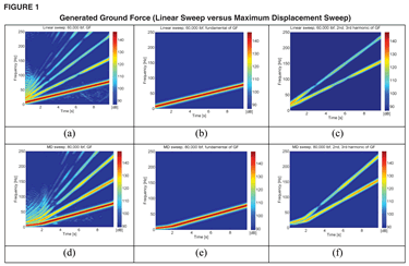
Figure 1 is a comparison of the ground force generated by a conventional 60,000-pounds/foot vibrator shaking a linear sweep versus an 80,000-pounds/foot vibrator shaking a maximum displacement sweep. It shows a time/frequency plot (a), an extracted fundamental plot (b), and extracted 2-D and 3-D harmonics for the linear sweep (c). The images labeled d, e and f are the corresponding figures for the maximum displacement sweep.
To address geophone attenuation on land, improved results are evident when swapping from a conventional geophone to a geophone accelerometer (GAC). The GAC is a motion sensor with significantly reduced signal distortion and increased bandwidth. This has been accomplished by enhancing the performance of proprietary 18-Hertz geophones with additional electronic circuitry originally developed in Japan.
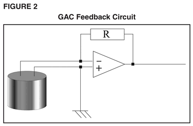
A GAC feedback circuit (Figure 2) provides reliable signal characteristics below 2.0 Hertz to provide a major reduction in signal distortion, which has been the chief impediment to quality recording of low frequencies. Elegant in its simplicity, but profound in its affect, a GAC connects the geophone across the input of an operational amplifier (OpAmp). A feedback resistor connects the OpAmp output to the geophone element. When the GAC coil moves within its magnetic field, the voltage it generates is detected by the OpAmp circuit, which responds by sending a current back through the feedback resistor, thereby heavily dampening the coil movement.
Because the force necessary to hold the coil stationary is proportional to the coil acceleration, the output voltage of the GAC device represents the earth motion expressed as acceleration. Since the coil movement is reduced by more than an order of magnitude, the associated signal distortion also is reduced by a similar order of magnitude. The GAC negative feedback loop widens the pass band of the signal it controls. Therefore, an 18-Hertz geophone equipped with GAC technology becomes an accelerometer with the -3 decibel point below 2.0 Hertz. An 18-Hertz geophone was chosen because the stiffness of its springs and the reduced coil displacement allow it to work in any orientation, optimizing the characteristics of the pass band.
Circular Geometry Acquisition
Offshore, the development of a new automated vessel, source and streamer steering system has enhanced the value and capabilities of marine technology. Already proven effective at enabling the acquisition of high-quality time-lapsed seismic data under extreme sea conditions, the technology has now taken a leap with the introduction of the circular geometry acquisition technique (Figure 3). Circular geometry acquisition is a highly-efficient technique that provides excellent 3-D coverage, as demonstrated by applications in the Gulf of Mexico and Black Sea.
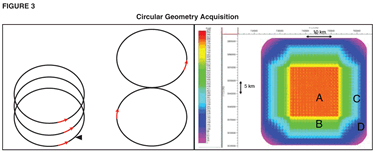
The technique provides 3-D areal coverage with a single boat in a fraction of the time required by traditional marine acquisition. It essentially establishes and maintains the precise position of each hydrophone in each streamer relevant to the tuned and calibrated air gun array. Automated vessel, source and streamer steering technology can maintain streamer interval during line changes, allowing data acquisition while turning. This quality is the key to circular geometry acquisition, which is an acquisition pattern consisting of overlapping circles of continuous shooting with no dead time
Steerable streamers have also emerged as enabling technology to overcome severe ghosting, which has previously inhibited low-frequency signal content required for imaging beneath highly absorptive subsea strata such as basalt and salt. The extension of lower frequencies also improves steep dip imaging and makes seismic inversion less dependent on model-based methods.
Traditionally, towed streamer systems deploy sources and streamers between 22 and 33 feet beneath the surface. This enables recording of the high frequencies required for resolution, but attenuates the low frequencies required for deep imaging, as well as stratigraphic and structural inversion. Shallow towing also makes the system more susceptible to environmental noise caused by wave, wind and sea current action. Conversely, deep towing can get away from the environmental noise and boost the ability to record lower frequencies, but will attenuate the high frequencies.
Accordingly, in the past, survey designs often were a compromise to optimize bandwidth and signal-to-noise ratio for a specific target depth, often at the expense of shallower or deeper horizon imaging.
Over-And-Under Technique
The advent of steerable streamer technology has provided a solution. Using an over-and-under technique enabled by steerable streamers and automated vessel, source and streamer steering technology, an acquisition array can be designed that preserves the best qualities of both shallow and deep source/streamer deployment.
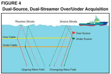
The basic design calls for a pair of streamer/source arrays (Figure 4). Data from both arrays are combined into a single data set that eliminates the debilitating ghost echoes that have historically plagued data quality. The over/under idea is not a new one, but it was previously considered impractical because there was no way to control the streamers relative to one another. Obviously, for effective deghosting, the vertical and horizontal offset of the two streamers must be maintained (typically within a few meters).
With automated vessel, source and streamer steering, it is now possible to deliver the positioning accuracy necessary to achieve the benefits of the dual-source, dual-streamer over/under technique and achieve highly-effective deghosting. Streamers can be steered to manage both the vertical and lateral relative streamer displacements within acceptable tolerances, even under adverse sea and weather conditions.
Together, continued technological improvements in seismic acquisition are allowing operators to choose sampling that is most effective for imaging their reservoirs, be it deep or shallow, on land or offshore. With the ability to reliably derive absolute rock properties with confidence from seismic data, geoscientists and engineers are one giant step closer to being able to accurately predict reservoir properties–a major milestone on the road from seismic to simulation.
JAMES MARTIN is vice president for research, engineering, manufacturing and sustaining at WesternGeco. He joined Schlumberger in 1994. Martin’s previous positions have included research director for the geophysics department at Schlumberger Cambridge Research in the United Kingdom and technology center manager in Fuchinobe, Japan. He holds a Ph.D. in geomagnetism from the University of Newcastle upon Tyne.
CLAUDIO BAGAINI is the principal research scientist based at the Schlumberger Cambridge Research Center. Prior to his current assignment, he was the program manager for seismic at the Schlumberger Dhahran Carbonate Research Center in Saudi Arabia. Bagaini has a Ph.D. in geophysics and a master’s in electrical engineering from the Polytechnic Institute in Milan, Italy.
For other great articles about exploration, drilling, completions and production, subscribe to The American Oil & Gas Reporter and bookmark www.aogr.com.