


Seismic Technology
Advances ‘Scale Up’ Nodal Acquisition
By John Smythe
HOUSTON–Oil and gas companies are continuously pressured to not only do more with less, but do it faster, safer and cheaper. This “new normal” in oil and gas operations, spurred by market volatility, makes it more important than ever to mitigate risk and uncertainty as much as possible in exploration, drilling, completion and production workflows. It also is driving significant new digital oil field and geophysical innovations, including in seismic data acquisition.
Seismic technology is the key to unlocking predictive certainty and effective reservoir management. In fact, whether onshore or offshore, a reservoir’s economic performance over its full life cycle is linked directly to the quality of the seismic data used to image the subsurface, assess recoverable reserves, mitigate risk and guide drilling and development decisions.
When it comes to seismic, image really is everything.
That largely explains why, even with all the technological advancements taking place throughout the industry, oil and gas operators still tend to embark on exploratory drilling with a certain amount of trepidation. They know any exploration project has relatively high levels of uncertainty and risk, and a lack of confidence in the seismic data will only increase the risk profile and reduce the probability of a successful drilling outcome.
As always, oil and gas companies are utilizing a variety of available data to manage that uncertainty–from seismic and geologic data to well logs and production histories–but the industry is only beginning to explore the frontiers of machine learning and artificial intelligence to assimilate the vast amounts of raw data pouring every day into corporate information technology systems. Data from Industrial Internet of Things-enabled sensors can be synthesized to generate real-time actionable data that was not previously available.
FIGURE 1
Ocean-Bottom Seismic Data Acquisition with Nodes
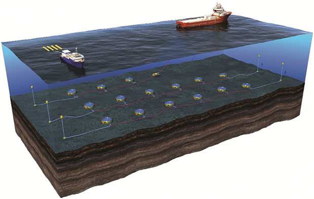
Similarly, seismic solutions are evolving and scaling up for application across the full life cycle of an oil and gas asset. A case in point is nodal seismic technology. Initially envisioned as a production tool, the nodal method historically has been applied in smaller-scale surveys acquired later in the reservoir development process to enhance production and extend a field’s economic life. However, advances in data recording and processing capabilities now make it economically feasible to scale up nodal acquisition systems to exploration-type surveys (Figure 1).
While nodes are being deployed in onshore horizontal resource plays and in shallow-water offshore blocks, the ability to efficiently conduct large-scale nodal surveys is a true game changer for deepwater operators. They now can benefit from the superior imaging results the technology makes possible beginning at the exploration stage–and extending throughout each subsequent phase of a deepwater field’s life–to significantly improve the quality of the 3-D data that geoscientists and engineers use to find and develop reservoirs in this higher-cost environment. Even legacy towed-streamer data can be improved with information gained from node surveys.
Life-Of-Field Application
In the exploration phase, regional reconnaissance and drilling prospect identification are the greatest concerns. Off shore, exploration often occurs in remote and difficult-to-access areas, environmentally sensitive waters, areas of dense infrastructure, and/or geologic basins with complex overburden, structure and stratigraphy.
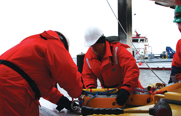
Advanced ocean-bottom nodal systems balance the competing exploration objectives of high-quality imaging, large-scale affordability, acquisition efficiency and minimal health, safety and environmental impact. Placing autonomous, cable-free nodes on the seafloor to acquire data allows operators to circumvent the surveying constraints and operational issues associated with towed streamers, while capturing previously unavailable data, even in areas in mature offshore basins with dense infrastructure.
Once operations move into the appraisal phase, the role of seismic shifts from regional reconnaissance to minimum economic field size identification. Seismic is a valuable tool to solve the problem of estimating reserves and economic reservoir limits, along with well and platform locations and recovery strategies.
Development and enhanced recovery phases force operators to again shift gears to focus on reservoir management and characterization. The data collected from nodal technology are rich, with full azimuths, long offsets, high vector fidelities, good coupling, high signal-to-noise ratios, and most importantly, excellent repeatability. These attributes make it ideal for 4-D time-lapse reservoir monitoring to detect subtle changes and measure the effectiveness of enhanced oil recovery methods. Detailed 4-D analysis also can identify bypassed reservoir compartments that are not being depleted effectively.
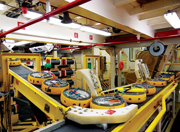
Node technology has been extended to semi-permanent reservoir monitoring. This type of node has a five-year deployment life, 500 days of data recording capacity and an optical data harvesting system, allowing for multiple time-lapsed monitoring surveys before node recovery. Monitor surveys are single-vessel operations, and seafloor node layouts can be reconfigured or expanded as field development plans are revised.
The development of nodal technology and the creation of sophisticated imaging algorithms go hand in hand. These algorithms require the data that only nodes can deliver. The full-azimuth, long-offset data are a perfect complement for new imaging algorithms, such as full-waveform inversion (FWI), which requires ultralong offset and low-frequency data to produce greater detail and insights.
Nodes are highly scalable. That scalability enables the acquisition of fit-for-purpose surveys, and ultimately, large-scale surveys with long offsets and full azimuths, which enhance operator decision making. Fit-for-purpose scalable seismic surveys are becoming increasingly common. The sources for these ultralong offset surveys are 20-30 kilometers away from the nodes and very densely sampled in azimuth.
The latest trend is acquiring a “velocity survey” to create highly accurate velocity models to improve existing older seismic data that do not have the benefit of longer offsets. New imaging technologies that require ultralong offsets, full azimuths and low frequencies also are creating demand for unique acquisition geometries that only can be accomplished using nodes placed on the ocean bottom.
Design Flexibility
The design flexibility inherent in nodal acquisition enables large-scale, deepwater ocean-bottom surveys with multiple imaging objectives. Since the nodes have no fixed interval constraint, hybrid receiver geometries are possible that satisfy the competing objectives of dense subsurface sampling, long offsets and large area coverage. Recent studies have shown that typical node spacing of 400 meters can be increased to as great as 800 meters outboard of the primary imaging area without compromising the final image.
New data recording and processing capabilities make it economically feasible to scale up nodal acquisition systems for deepwater exploration surveys, significantly improving the quality of the seismic data available to guide drilling and development decisions. The full-azimuth, long-offset data and high survey repeatability make nodes ideal for full-waveform inversion and other advanced imaging algorithms, as well as time-lapse analysis to detect subtle reservoir changes over time.
This is important considering that the seismic objectives in deepwater field development often involve 3-D imaging beneath complex overburden, particularly below and around salt, where illuminating a formation of interest can be highly sensitive to the azimuth and offset of the source point relative to the node location. To optimize imaging beneath complex overburden, ocean-bottom node surveys are designed to illuminate the target area from all azimuths, and to do so continuously in offset out to a maximum distance suitable for the survey objectives.
As the field is produced, the seismic response of the reservoir changes over time. This enables operators to determine if parts of their reservoirs are not being depleted. By comparing year-one with year-two survey data, for example, inferences can be made about the effectiveness of well placement and how well the reservoir is being managed. Armed with this knowledge, operators can avoid leaving behind undrained reservoir compartments as well as potentially reducing the number of wells drilled without negatively impacting the bottom line.
Nodes are self-contained and require no cabling, minimizing the subsea footprint and ensuring high reliability and minimal gaps in coverage, even in areas with extensive infrastructure or high levels of surface activity. Moreover, because acquiring seismic data with ocean-bottom nodes is proven safe, an overwhelming number of oil and gas companies rely on the technology to maintain health, safety and environmental standards, accelerate production, reduce costs, and ultimately, increase reserves recovery.
Full-waveform inversion, 4-D analysis, and data analytics are the most significant trends impacting the life of a field. The adoption of ocean-bottom node acquisition has enabled the increasing use of these technologies. Velocity surveys, for instance, make FWI more accurate by adding the long-wavelength components missing from current models.
Analytics turn base data into tools that can predict rock properties and other critical parameters. More importantly, these trends, taken together, can lead to fewer wells being drilled without lowering production output. The combination of node data, flow simulations and other reservoir technologies derisks well planning and helps ensure uninterrupted production output.
Onshore Resource Plays
On shore, conventional formations are becoming the new unconventional formations in some instances, as operators deploy horizontal drilling and multistage fracturing in the Austin Chalk, San Andres, Green River Basin and other plays. Unconventional does not have to mean unpredictable if operators maximize the value from the data they acquire and apply an understanding of the geology to manage reservoirs with precision.
The high scalability, design flexibility and autonomous operation of nodes enable fit-for-purpose and large-scale survey configurations to acquire rich and high-density datasets for application throughout a field’s full life cycle. The latest generation of self-contained, cable-free nodal technology has a five-year deployment life and the ability to record 500 days of cumulative data before recovery.
In resource plays, nodal acquisition systems are delivering high-quality data to optimize stacked pay development strategies, including identifying patterns in natural fractures and predicting pore pressures to determine the most economical ways to space, drill and complete horizontal wells to maximize reserves recovery.
In a multiclient survey in Lea County, N.M., Dawson Geophysical is using Fairfield Geotechnologies’ autonomous node technology with tight vibrator spacing to acquire ultrahigh-resolution data with dense sampling and high-fold coverage. The acquisition parameters and processing sequence are designed specifically to address imaging problems caused by a complex near-surface geologic feature that is prevalent in the northern part of the Delaware Basin. Fairfield Geotechnologies’ nodal survey is in a regional area of mutual interest with TGS aimed at providing thousands of square miles of new data between the Delaware Basin and Central Basin Platform.
Data analytics is an integral part of being able to leverage all the rich data inputs available to extract the most predictive and actionable information operators can use. Because of the sheer magnitude of the information, unseen relationships that exist within big data require computers to detect. Node data play a very critical and foundational part in this, given that life-of-field decisions are impacted directly by seismic image quality.
With increasing business demands and HS&E issues, there is no doubt the future of the industry lies in integrating nodes, new imaging technologies and data analytics to generate the most accurate predictive output for conventional and unconventional reservoirs. The industry has recognized and embraced the value of nodal data acquisition systems, and as companies continue to expand the technology’s use, the industry will advance more novel uses and innovative commercial models to drive further efficiencies and safety improvements.
Operators need to make the right decisions quickly and safely, but obtaining data is only the beginning. Understanding how to use the information is key to unlocking its benefits. Data technology, in all of its forms, is about the life of a field and maximizing current assets. Some operators have used seismic reservoir characterization tools and data analytics to greatly reduce their costs while increasing their outputs through a greater understanding of cause and effect. Investing in seismic data, high-resolution imaging and data analytics will help create a sustainable, profitable business.

JOHN SMYTHE is vice president of technical sales and marketing at Fairfield Geotechnologies. With nearly 40 years of experience in seismic technology, he began his career as a geophysicist at Amoco Production Co. and subsequently served as a senior geophysicist at both major and independent oil and gas companies before joining Fairfield Geotechnologies. Smythe holds a B.A. in geology from Boston University and an M.S. in geology from Rensselaer Polytechnic Institute.
For other great articles about exploration, drilling, completions and production, subscribe to The American Oil & Gas Reporter and bookmark www.aogr.com.