


Geosteering in Challenging Areas
Cross-Disciplinary Integration Optimizes Wellbore Geosteering In Parsley’s Trees Ranch Project
By Jennifer Hernandez, J. Alexandra “Ali” Sloan and John Terwilliger
AUSTIN–In addition to its leading Midland Basin acreage position, Parsley Energy Inc. has established a contiguous acreage position in the southern Delaware Basin in West Texas, which is prospective for multiple stacked stratigraphic layers and landing zones, including the Wolfcamp and Bone Spring formations.
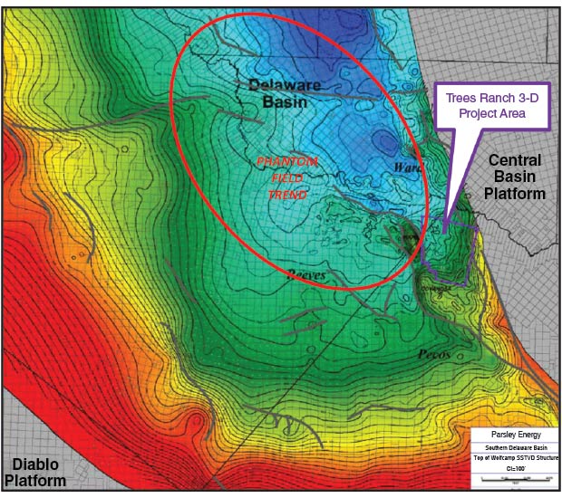
Initial horizontal drilling in the Delaware Wolfcamp play was focused in the Phantom Field trend, which is situated in the eastern portion of the basin where the Wolfcamp is deeper and thicker. More recently, development has pushed farther south into the more structurally complex portion of the basin. Deep-seated structural features influence the thickness and complexity of the Wolfcamp section throughout this region.
Parsley Energy’s Trees Ranch project in Pecos County is located in a unique portion of the southern Delaware Basin. It is bounded to the west by the Waha structure (a series of thrust faults and folds), to the east by the Central Basin Platform, and to the southwest by the Coyanosa anticline structure. The Wolfcamp formation on these bounding structures is thin to nonexistent. Within Trees Ranch, the Wolfcamp’s thickness is similar to the prolific Phantom Field trend that extends into Ward and Loving Counties.
Parsley has targeted the overpressured, high-resistivity Upper Wolfcamp through horizontal drilling in the project area with great initial success. Although the Wolfcamp is a prolific source rock and reservoir at Trees Ranch, initial stratigraphic correlations and geosteering are challenged by limited well control, along with localized debris flows and chaotic bedding, which are attributed to the proximity to the Central Basin Platform. These challenges exist throughout both the Bone Spring and Wolfcamp formations in this area.
Because of these challenges, 3-D seismic and cross-discipline integration between geology and geophysics have been instrumental to initial geosteering efforts for the company’s Permian Basin horizontal wells, which now are characterized by lateral lengths averaging more than 9,000 feet.
FIGURE 1
Southern Delaware Basin Wolfcamp Structure Map
In order to plan and execute an active horizontal drilling program in an area such as the Trees Ranch project (Figure 1) with minimal subsurface well penetrations, 3-D seismic interpretation is integrated with well data to achieve an understanding of the structural and stratigraphic changes. Known seismic acquisition issues in the southern Delaware Basin and variable pressure cells can cause velocity anomalies. Therefore, seismic is used as a general guide for expected structure and faulting along the lateral.
In undeveloped areas, 3-D seismic depth maps are integrated with limited log data throughout the development process. Prior to drilling, the geologist correlates well logs throughout the area to understand general structure and thickness changes. The geophysicist integrates these tops into the seismic depth maps to generate a more accurate subsurface picture, which then aids the geologist in anticipating formation changes and landing within the desired target interval.
During the drilling process, the geologist monitors measurement-while-drilling gamma ray. Major formation tops encountered are correlated back to the seismic and used to adjust the target landing depth in real time. Throughout the lateral, gamma ray correlations and mud log data are used to provide more detailed estimates of formation dip to allow the wellbore to remain in the preferred flow unit.
In the post-drill analysis, the target zone’s formation is projected from geosteering software and incorporated into the seismic depth interpretation to update structure maps and assist in creating directional plans for future laterals. The iterative process of integrating and re-interpreting 3-D seismic and subsurface well log data is essential to accurate and effective geosteering of horizontal wells and successful development of closely spaced target zones in an unconventional play.
Data Integration
Parsley Energy has acquired proprietary 3-D seismic data across the southern Delaware Basin that is used to produce integrated structure maps utilized for well planning and as an aid for geosteering. Seismic subsurface imaging in this area is known to be difficult as a result of shallow, near-surface variations that must be accounted for during data processing. Even with lower-frequency content data obtained, seismic images are invaluable for mapping the Wolfcamp section.
Because of local stratigraphic changes occurring below seismic resolution, the geologist and the geophysicist work as a team to utilize well control and seismic data as a predictive tool in preparing a “geoprognosis.” Drilling geohazards, such as faults and/or near-surface karsting identified by seismic, are communicated to all parties responsible for well operations to reduce drilling risk. Seismic structure maps are converted to depth and used in both pre- and post-drilling analyses.
The Trees Ranch 3-D seismic data cover an area where the Wolfcamp’s lithology is highly variable and differing pressure cells exist within the Wolfcamp section, as inferred by the seismic stacking velocity. Both of these factors may cause erroneous structural exaggeration to appear on a seismic depth map.
To create seismic structure maps in depth, the time-interpreted seismic horizon is converted to depth by incorporating the geologist’s well markers to the seismic data. In the Trees Ranch 3-D area, there are a limited number of deep well penetrations with gamma, sonic and density data that are used to create synthetic seismograms to tie well data to the seismic interpretation. After tying vertical well subsurface marker data, a seismic time-to-depth conversion velocity grid is computer-generated.
The velocity grid also is hand-edited to add any needed bias, which may account for local depositional changes predicted by existing well control. For example, carbonate content increases with closer proximity to the Central Basin Platform. The geophysicist’s depth structure map on the targeted horizon then is integrated with the existing geologic prognosis to create a directional plan for the drilling engineer.
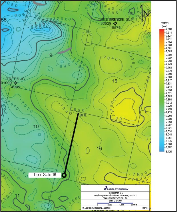
FIGURE 2
Trees State No. 16-1H Pre-Drill Seismic Depth Map
Additional preparation includes estimating the major formation top depths, landing depths and trajectory of the desired horizontal target. A series of subsurface structure and isopach maps are utilized to create the well’s initial prognosis, and then further refined through integrating the seismic depth map of the targeted horizon.
While drilling the vertical and curve sections of a well, the geologist and geophysicist are in close communication to ensure interpretations are correlated. The team uses MWD gamma ray to pick major formation tops using a cross-section of nearby wells, and compares them with the pre-drill seismic depth map to see how they align with the prognosis tops. If discrepancies exist between the predicted and actual tops, the geologist and the geophysicist team works together to determine a projected plan to safely land the lateral into the desired target window.
A new depth structure map is created after encountering the top target zone and the directional plan is adjusted. The changing stratigraphic nature of the Upper Wolfcamp can make MWD gamma ray quite difficult to correlate. Having a series of type logs across the length of the wellbore can be beneficial. In areas where well control is sparse, seismic may be the only guide for estimating formation dip.
Formation Dip
When Parsley Energy drilled its first horizontal well in the Trees Ranch area, the Trees State No. 16-1H, the seismic depth structure map (Figure 2) indicated the Wolfcamp formation would rise 60 feet over the 5,000-foot lateral length. However, the geosteering interpretation using MWD gamma ray yielded a depth structure map that had a flat to slightly updip structure, only rising approximately 10 feet from heel to toe (Figure 3).
FIGURE 3
Trees State No. 16-1H Geosteering Plot
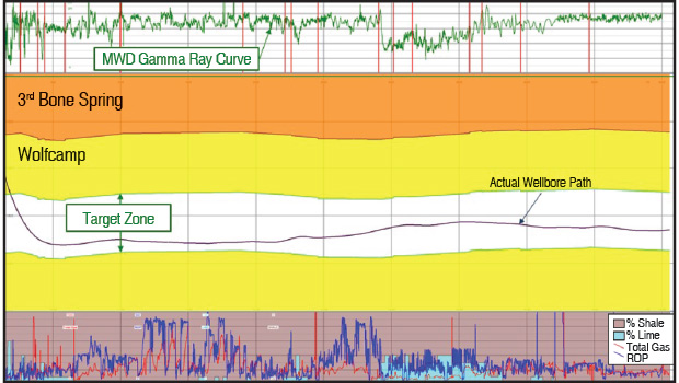
FIGURE 4
Post-drill Seismic Depth Map for Trees State 16-1H And Trees State 14-15-4301H
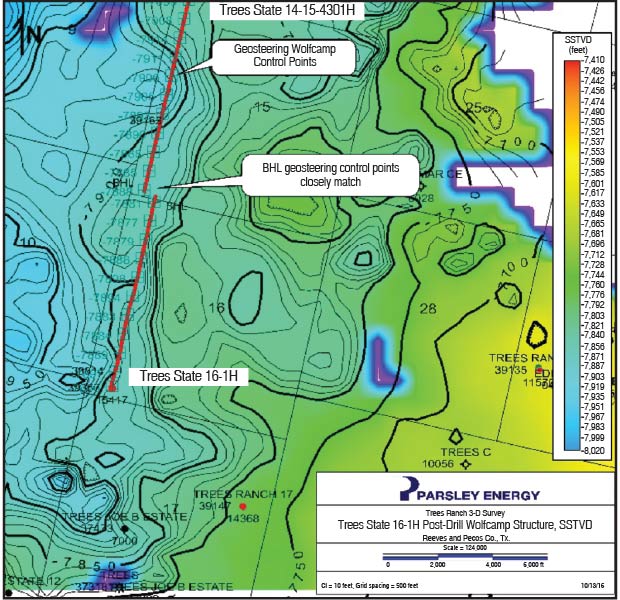
Later, the MWD gamma ray depth map interpretation was confirmed when Parsley drilled the Trees State No. 14-15-4301H lateral that came toe-to-toe with the Trees State 16-1H. The projected true vertical depth top of the Wolfcamp at total depth came within 10 feet of the projected TVD top of Wolfcamp at total depth on the Trees State 16-1H. In this instance, seismic data integrated with geology was used as a tool to predict formation dip prior to drilling, while drilling the lateral, and later was refined after both wells reached total depth.
Once a well has reached its total depth, the actual well markers are incorporated into the seismic depth map along with the geosteering interpretation if there is a high confidence in the correlation. During this process, the geophysicist selects a regular gridding interval that fits the map data (i.e., every 400 feet or so) to recalculate and revise the seismic depth map to match the interpretation (Figure 4).
With limited well control in an area of complex stratigraphy, the Trees Ranch proprietary 3-D dataset has been essential to the initial success of Parsley Energy’s horizontal campaign in the southern Delaware Basin. Integrating the geology with the seismic has allowed for a more accurate depiction of the subsurface. Issues with seismic image quality and formation pressure variability in the area can create erroneous structures, but these are becoming more predictable as the seismic depth maps are fine-tuned with every new data point collected.
Having seismic as a guide to aid in geosteering for predicting structural changes is a key component in executing a successful drilling program. Drilling these horizontal wells within the desired target window becomes more important as Parsley Energy evaluates moving to tighter-spaced vertical and horizontal target zones on multiwell pads.

Jennifer Hernandez joined Parsley Energy as a geologist in 2014 and currently is working the company’s Delaware Basin asset. She has more than a decade of industry experience, with a focus on operations and field development. Hernandez holds a B.S. in geology from the University of Texas at Austin.

J. Alexandra “Ali” Sloan is a geologist at Parsley Energy, where she works on the Delaware Basin development team. Before joining the company, she worked for Marathon Oil Corp. Sloan holds a B.A. in geology from The College of Wooster and an M.S. in geological sciences with an emphasis in petroleum and subsurface modeling from the University of Colorado at Boulder.

John Terwilliger is a member of Parsley Energy’s Delaware Basin team focused on Wolfcamp development. He has more than two decades of experience in seismic interpretation and modeling in onshore U.S. conventional and unconventional plays. Before joining Parsley Energy in 2014, Terwilliger worked as a seismic interpreter at Statoil DPNA and Brigham Oil & Gas. He holds a B.S. in electrical engineering from the University of Connecticut and an M.S. in geophysics from the University of Houston.
For other great articles about exploration, drilling, completions and production, subscribe to The American Oil & Gas Reporter and bookmark www.aogr.com.