


Seismic Imaging
FAZ Optimizes Multiple Attenuation
By Duane Dopkin
HOUSTON–As seismic waves travel through the earth, they are dissipated through both absorption (anelastic attenuation) and wave path scattering (elastic attenuation).
Energy propagating through the earth also can reverberate and create energy referred to as “multiple energy.” This energy can significantly impair a geoscientist’s ability to interpret and prospect with seismic data. Consequently, despite significant advances in the science of multiple energy attenuation, it remains one of the most challenging areas for the seismic method.
Predictive, or data-driven, as well as model-driven methods continue to be modified to handle a complex range of multiple generating conditions in the presence of irregular water bottoms, shallow water, salts, volcanics, and high-reflectivity carbonate and anhydrite sequences.
While all these conditions can generate challenges for application geophysicists, it is the interbed multiples, which are generated from sequences of high-reflectivity formations, that can significantly compromise the use of seismic data for reservoir delineation and advanced characterization methods. Under these conditions, methods that attempt to exploit move-out differences between primaries and multiples fail.
One of the newer ways to address this interbed multiple problem, together with the broader range of multiple generating conditions, is using full-azimuth depth imaging and decomposition technology to attenuate or remove this undesirable energy from the seismic wave field. In this model-driven process, primaries can be distinguished from multiples, based on their respective energy distributions in “directivity” (dip-azimuth) space.
FIGURE 1
LAD Imaging System for Five-Dimensional Mapping of
Surface-Recorded Seismic to Subsurface Image Points
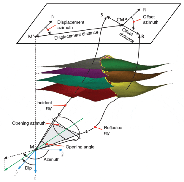
The full-azimuth imaging system is able to map and decompose surface-recorded seismic data into subsurface, multidimensional prestack image gathers. This mapping and decomposition technique is carried out with a special “bottom-up” ray tracing operator using an in situ reference system referred to as the local angle domain (LAD).
Five-Dimensional Gathers
Figure 1 illustrates the LAD imaging method, with the source point shown in red and the receiver point in green. The outcome of the ray tracing and mapping is a five-dimensional image gather described by full-azimuth subsurface directivity (the dip and azimuth of the local reflecting surface) and by full-azimuth subsurface reflectivity (the opening angle and its associated azimuth defined by the incidence and reflected ray pair).
Figure 2 shows examples of mapping surface-recorded seismic data to five-dimensional gathers of full-azimuth reflectivity and directivity, and displaying the results in 3-D or 2-D forms. This multidimensional decomposition provides the highest levels of flexibility in designing special imaging and inversion operators to emphasize or attenuate different subsurface features. Specifically, the technology can be applied to:
FIGURE 2
Full-Azimuth Surface to
Subsurface Mapping
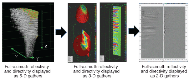
- Enhance continuous reflections in the presence of low signal-to-noise with operators that emphasize “specular energy;”
- Recover the low energy associated with small faults, discontinuities or feature edges with operators that emphasize “diffraction energy;”
- Map in situ stresses and natural fractures using full-azimuth reflectivity data, and full-azimuth amplitude-variation-with-azimuth and velocity-variation-with-azimuth inversions; and
- Differentiate between primary and multiple data.
Multiple Suppression
Two approaches can be used to attenuate the broad spectrum of multiples that may be present in the fully recorded seismic wave field. Both methods exploit the “directionality” of the imaging operator and associated multidimensional gather output.
The first approach is based on the internal (imaging) implementation of local slant stack (LSS) operators, optimally designed for each primary ray pair associated with a given source-image/point-receiver path, and the corresponding seismic data event. The LSS is applied in the direction of the horizontal “slowness” components of the arriving rays at the acquisition surface, where the size of the LSS (the number of traces involved) is computed independently for each ray pair from its first Fresnel zone (a region defining the lateral resolution of seismic data).
Therefore, primary reflection events sharing the same travel time and the same surface directivity as the traced ray pairs are emphasized (highly weighted), while all other events (considered as noise) are attenuated simultaneously.
FIGURE 3
Full-Azimuth Directivity
Gather with Depth,
Dip and Azimuth
Energy Distributions
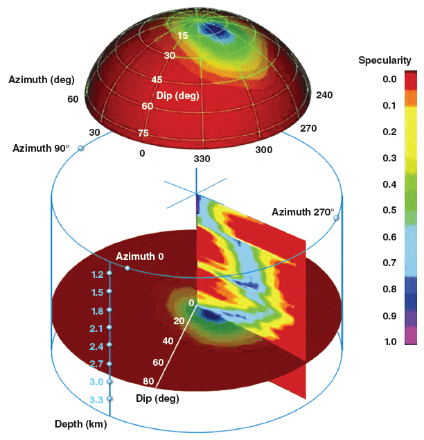
In the second approach, the full-azimuth directivity gathers are used to identify the respective energy distributions of primary and multiple events in both dip and azimuth. Special operators are designed to subsequently remove the multiples with different dip and/or azimuth energy distributions from the primaries. This approach can be quite effective at attenuating interbed multiples, particularly if there is any structural separation of primary and multiple events.
Figure 3 shows a full-azimuth directivity gather with energy distributions over depth (vertical axis), dip and azimuth. Contributions of energy can include primary specular energy, diffraction energy, and multiple energy.
These approaches are highly complementary, and in practice, are used together to optimize the removal of multiple energy, where the full-wave-field imaging solution coupled with a predetermined set of conditions is used to isolate primary energy from multiples. The predetermined set of conditions can be unique to the primaries and can include, for example, specific arrival directions, travel times, directions of reflected signals, angles of reflection, arrival locations on a free surface, or any other suitable conditions or combination of conditions.
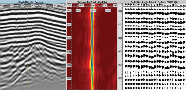
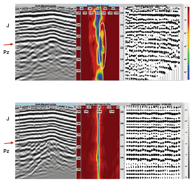
FIGURE 4
Kirchhoff PSDM (Top) versus
Full-Azimuth Imaging And
Decomposition (Bottom)
Source: Aleksander Inozemtsev, Zvi Koren and Alexander Galkin, Paradigm, “Noise Suppression and Multiple Attenuation using Full-Azimuth Angle Domain Imaging: Case Studies,” First Break, Vol. 33, June 2015
Field Example
Figure 4 shows a comparison of multiple suppression efficiencies between a Kirchhoff prestack depth migration (top) and full-azimuth imaging and decomposition (bottom) focused on multiples attenuation along a Jurassic and Paleozoic basement in a study area with geologic conditions that challenge conventional seismic processing and imaging.
The recorded seismic data in this area are characterized by a large number of different order, high-amplitude multiples. The multiple events are generated from different depth interfaces between various rock types, starting from the Upper Cretaceous clastic sediments at the shallow to medium parts of the subsurface, and going deeper.
When using Kirchhoff PSDM, the shape of the low-amplitude migrated reflectivities was distorted by the interbed multiples. A multiple reflection event crossing the entire lateral range strongly dominates this area, forming a complex image that barely can be interpreted.
On the other hand, full-azimuth imaging and decomposition migration technology provide a clearer and more realistic image of the complex geological structure of the Paleozoic basement. Additionally, a system of subvertical faults and clear boundaries between the Jurassic and Paleozoic basement are visible and interpretable using full-azimuth imaging and decomposition.

DUANE DOPKIN is executive vice president of geosciences at Paradigm. In his 30-year career at Paradigm, he has held numerous leadership positions in research and product management. Prior to joining Paradigm, Dopkin worked as a geophysicist at Digicon Geophysical Corporation, and served as manager of special products and vice president of research at CogniSeis Development, a geosciences software company that later was acquired by Paradigm. Dopkin holds a B.S. in geosciences from Pennsylvania State University and an M.S. in geosciences from the University of Houston at Clear Lake.
For other great articles about exploration, drilling, completions and production, subscribe to The American Oil & Gas Reporter and bookmark www.aogr.com.