






Multidisciplinary Workflows Provide Holistic Perspectives, Optimize Unconventional Plays
By Peter Flanagan and Rachel Stocking
As operators increasingly evaluate Tier 2 inventory, optimize infill development, and pursue more technically challenging reservoirs, the margin for error narrows. Successful development increasingly depends not only on drilling wells efficiently, but also on understanding how geologic complexity, well placement, completion design, and reservoir behavior interact.
A March 2026 analysis by McKinsey & Company illustrates what is at stake. Outside the Permian and Appalachian basins, it estimates most U.S. shale plays have less than four years of Tier 1 locations remaining at the industry’s 2024 drilling pace. Fortunately, emerging technologies and practices could upgrade 55,000 to 80,000 Tier 2 locations to Tier 1 economics over five to ten years. The study notes that the amount depends on adoption at scale and price and operating assumptions.
Many emerging technologies, such as next-generation subsurface characterization and AI-assisted development design, require companies to master the art of quickly sharing structured data across disciplines.
Interpretation, drilling measurements, and completions modeling have advanced substantially, but teams still often work in separate software environments. Even though operators have access to more subsurface information than ever, it’s often unnecessarily difficult to turn that information into a coherent understanding of the reservoir.
A new generation of connected software is beginning to change that.
Cloud-native architecture, structured geospatial databases, application programming interfaces (Web APIs), and automated data exchanges are making it increasingly practical to connect specialized applications and the teams that use them. AI technology amplifies the benefits that this new ecosystem provides.
The opportunity is not simply to move data faster. It is to preserve the geologic and operational context that gives data meaning—and place greater control over that information in the hands of operators to tackle the Tier 2 challenges ahead.
Why Silos Must Go
A geologic interpretation may originate in one application, be exported for well planning, transferred again for real-time geosteering, and eventually reconstructed to support completions analyses. A geologist’s recommended target change requires drilling engineer approval. These workflow “friction points” hinder exploration and production professionals and limit efficiency.
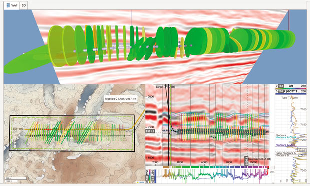
By placing completion designs in their geologic context, development teams can deepen their understanding of well performance. Such integrated views can also enable them to significantly reduce the risks associated with completing wells in naturally fractured and structurally complex formations. Top: fracture wings against seismic. Lower left: completions on a structural map with acreage and drilling spacing unit boundaries. Lower right: completions, geosteering interpretations, and seismic in cross-section.
As they work with constantly reconstructed data, teams may encounter differences in coordinate reference systems, well identifiers, depth references, data versions, and interpretations. Even when the underlying information is technically available, reconciling it can require considerable effort.
An integrated workflow addresses this challenge by establishing reliable relationships between datasets and allowing information to move between applications without repeatedly rebuilding its context.
The consistent, accessible, governed information does more than simplify transfers. It allows specialized applications to contribute to a broader understanding of the subsurface, while creating a more satisfying and productive collaborative environment.
Essential Architecture
Legacy software environments tend to be closed systems, difficult to adapt and integrate—the “walled garden” model. Modern cloud architecture offers a different, more open and flexible model.
Cloud-native applications have a natural architectural advantage: centralized databases accessible through documented Web APIs, with browser-based delivery bringing geoscience, drilling, and completions teams into the same working environment. Together, these attributes make collaboration practical at the pace of operations.
The objective need not be to replace every specialized tool. In fact, reliable exchange allows operators to combine commercial applications with internal analytics, automation, and AI. Technical teams can address their own challenges without waiting for a vendor to develop every capability.
Rather than organizing workflows around application boundaries, operators gain freedom to organize software around how their teams work. Ownership, security, permissions, licensing, and interface standards still require attention, and connectivity varies between systems.
Nevertheless, the direction is clear. Software’s value will increasingly depend on how effectively it supports the operator’s broader technology strategies and environments, and cloud-native systems offer a practical path toward that goal.
Geospatial Reconciliation
For subsurface applications, connectivity presents a particularly compelling opportunity. When operators can look at all the geologic and operational data at their disposal, they end up with a much clearer understanding of the subsurface.
In a single area, a seismic interpretation images a geologic structure. A well survey describes the path a borehole takes through that structure. Formation tops establish stratigraphic relationships between wells. Drilling measurements describe conditions encountered along the wellbore. Completion stages and fracture interpretations describe how the reservoir is stimulated.
FIGURE 1
Production Uplift In Austin Chalk Developments
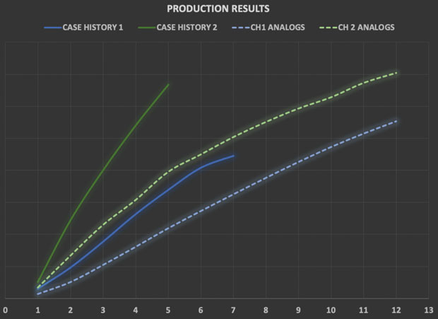
This figure compares cumulative production across time in months for the two Austin Chalk developments discussed (the solid lines) with that of nearby analogs (the dashed lines). The blue lines correspond with the first development, while the green ones correspond with the second. Both developments easily outperform their respective analog trends over the periods shown.
These datasets each provide a different perspective on the same physical environment. If they’re stored in disconnected files, it can be difficult to correlate their locations and consider multiple perspectives at once. But when they’re part of a structured, spatially aware database that preserves their geospatial relationships, information can be combined in powerful ways.
Drilling engineers can evaluate trajectories against existing wells and surfaces. Geologists can incorporate updated surveys and logs without losing structural context. Completions engineers can examine stimulation designs alongside interpretations developed during drilling.
The benefits extend beyond visualization. Reliable alignment reduces duplicate work and reveals discrepancies before they affect decisions. Formation tops support updated contour maps, trajectories can be checked against neighboring laterals, and new measurements can be linked to existing records.
Advanced geospatial capabilities reduce the pain of reconciling operational data, improving accuracy and efficiency. Browser technology brings that shared subsurface view across the organization and the operator’s contractors.
When Complexity Raises Stakes
In naturally fractured and structurally complex formations such as the Austin Chalk, well placement and completions performance should not be evaluated independently. Fault geometry, natural fracture networks, stress orientation, and well position can influence drilling and stimulation—and can yield dramatic benefits.
One Austin Chalk operator offers a practical example of carrying subsurface understanding across disciplines, from planning through production. Across two developments, geoscience and completion teams aligned seismic fault interpretations, resistivity-derived image logs, and geosteering interpretations in a shared subsurface view. They used fault orientation relative to maximum horizontal stress to anticipate activation and shear slip potential to identify risks to casing integrity and assess potential communication with depleted intervals.
During stimulation, real-time pressure responses in nearby Eagle Ford parent wells allowed the teams to test those predictions together and distinguish poroelastic responses from evidence of hydraulic communication.
In the first development, screen-outs clustered near interpreted fault activation. The team interpreted this as proppant bridging in narrowing fracture apertures and switched to smaller proppant. After that change, screen-outs largely subsided.
Those findings informed the second development’s design and preparations for screen-outs and casing deformation. Acoustic borehole imaging confirmed restrictions near predicted casing deformation locations anticipated from the seismic volume. Smaller perforating guns and an unconventional casing strategy helped preserve access. The workflow carried geologic interpretation into operational decisions, then used diagnostics to test and refine it.
Production data in the initial months showed both developments outperforming their respective nearby analog trends, with the second development following a production trend nearly twice as strong as the first (Figure 1). Gas-tracer diagnostics on selected contrasting stages in two wells from the second development provided another geologic link. Over a 90-day period, tracer data showed that faulted intervals averaged 48.6% greater normalized relative hydrocarbon contribution than corresponding non-faulted intervals across two landing-position categories.
That measure reflects relative tracer behavior, not absolute stage production or recovery factor. However, the operator interpreted it as consistent with faults helping drain more target height. Neither the tracer results nor the production trends isolate causation: geology, landing position, completion design, and other conditions differed between developments.
But the results fit a common pattern: When teams have a shared view of the physical environment, they achieve greater performance. In this case, geological predictions informed completion decisions, pressure monitoring tested anticipated fault behavior, and production and tracer diagnostics helped teams interpret the outcomes. Rather than skipping potentially productive faulted stages, the operator used that shared understanding to manage their risks.
Making these connections practical within operational time constraints is the broader opportunity. Less time reconstructing context gives teams more time to act on it, and supports a repeatable learning process that can turn incremental improvements into meaningful gains across a development program.
The same principle applies to increasingly complex well geometries. Operators use U-turn laterals to access targets within surface, lease, or subsurface constraints. Coordinated map, cross-sectional, and three-dimensional views help evaluate planned and actual wellbores against nearby wells and geologic targets, improving drilling efficacy in these notoriously difficult-to-execute drilling scenarios.
A Vital Foundation
The emergence of artificial intelligence is adding urgency to the need for well-structured, connected subsurface data.
AI systems can help users find and integrate data, automate repetitive tasks, generate visualizations, and explore relationships across large datasets. But their usefulness depends heavily on the quality, accessibility, and context of the underlying information.
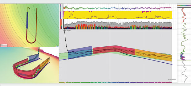
When placing U-laterals or other wells with complex geometries, it’s important to evaluate planned and actual wellbores against nearby wells and geologic targets. This coordinated view shows a map at upper left, 3D wellbore with drilling data at lower left, and a measured-depth section with interpretations and horizontal log and drilling-data tracks at right.
The most promising applications will combine automation with a structured data environment, transparent methods, and expert oversight.
Consider a geologist asking an AI assistant to identify wells penetrating a formation and generate a contour map from their tops. Executing that request requires more than interpreting natural language. The system must identify wells, locate tops, reconcile spatial references, and apply suitable interpolation. Experts must still review data quality, geologic plausibility, and uncertainty. The underlying database and its relationships are what make this type of AI-powered workflow possible.
AI’s reliability therefore depends on a connected, governed body of subsurface knowledge that analytical tools can access alongside established applications. With such a data environment and guidance from experienced E&P professionals, the impact of AI on our industry is likely to be profound.
Building that environment does not require replacing every specialized tool with a single system. In fact, it should give operators even greater control over their technology strategies. When every tool has easy access to geospatially consistent data, operators can combine commercial software, internal applications, and AI assistants without worrying about the time lost to transferring and reconciling data. This should empower them to create flexible workflows that target their current challenges.
For software providers, connectivity presents an opportunity as well. As an application’s value rises not based solely on its independent capabilities, but also on its contribution to a connected operational environment, the business case for investing in applications will grow. However, this only applies to ones that have a documented Web API for securely exchanging data while preserving technical context.
As shale development advances into more complex geology and increasingly demanding economics, that distinction will matter. Incremental improvements in well placement, stimulation designs, and production can become consequential across a development program. Even modest recovery factor gains can matter at scale.
But given the remarkable strides the industry has already made and the fascinating complexity of the subsurface environment, turning those small steps forward into routine events often demands multidisciplinary workflows. In the fiercely time-stringent environment of drilling and completing unconventional horizontal wells, these workflows must be simple enough to implement quickly.
That is where connected software comes in. By removing the walls between disciplines, it can turn the subsurface operational data companies collect during shale development into an invaluable digital asset that teams can leverage in many ways. The resulting insights will empower operators to unlock the value hidden in their assets, transforming acreage they would have once considered second-tier into a capital magnet that will sustain U.S. production.

PETER FLANAGAN is the CEO of Ubiterra Corp., the developer of ZoneVu®, a cloud and browser-based software solution that connects geologic and operational information across drilling, geosteering, and completions. Flanagan has spent decades creating software to solve industry challenges. Before founding Ubiterra in 2011, he launched Oildex, an online data exchange and workflow solution, in 1999.
Earlier in his career, Flanagan served as geophysical product manager for the Landmark/Geographix division at Halliburton. He also started two companies that refined techniques for understanding seismic, Reflection Software and Parallel Geosciences. Flanagan began his career in 1983 as a geophysicist with Amoco Production Co.

RACHEL STOCKING is the vice president of strategic growth for ZoneVu® at Ubiterra Corp, where she has worked for six years. She has extensive experience promoting software and services that help users get practical insights from subsurface data. Her past roles include business development manager for Deep Imaging, sales representative for ESG Solutions, account manager for Spectraseis, and business development manager for NodalSeismic.
Stocking began working in the oil and gas industry in 2011, when she joined the public/community relations and government affairs team at California-based Signal Hill Petroleum. Before that, she spent six years as a media buyer, public relations representative and account executive at advertising agencies.
For other great articles about exploration, drilling, completions and production, subscribe to The American Oil & Gas Reporter and bookmark www.aogr.com.